1964 Savage Mountain B-52 crash
|
10 January 1964: 3 days before the Savage Mountain crash, a New Mexico B-52 test showed the vertical stabilizer could fail. | |
| Accident summary | |
|---|---|
| Date | 13 January 1964 |
| Summary | Structural failure |
| Site |
Savage Mountain, Garrett County (near Barton, Maryland) 39°33′55″N 79°04′33″W / 39.565278°N 79.075833°WCoordinates: 39°33′55″N 79°04′33″W / 39.565278°N 79.075833°W |
| Crew |
5: |
| Fatalities | 3 |
| Survivors | 2 (Pilot, copilot) |
| Aircraft type | Boeing B-52D Stratofortress |
| Operator | 484th Bombardment Wing, Heavy (SAC, United States Air Force) |
| Registration |
55-060 (c/n 464012,[2] call sign "Buzz 14") |
| Flight origin | Westover Air Force Base |
| Destination |
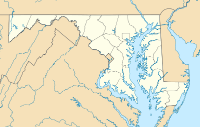  Crash site Barton, MD Crash site in Maryland |
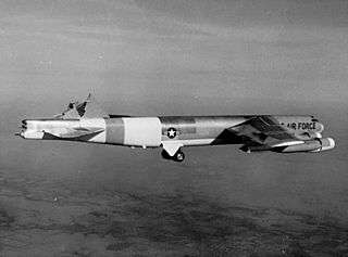
The 1964 Savage Mountain B-52 crash was a U.S. military nuclear accident in which a Cold War bomber's vertical stabilizer broke off in winter storm turbulence.[3] The two nuclear bombs being ferried were found "relatively intact in the middle of the wreckage",[4] and after Fort Meade's 28th Ordnance Detachment secured them,[5] the bombs were removed two days later to the Cumberland Municipal Airport.[6]
Accident description
The B-52D was returning to Georgia from Massachusetts after an earlier Chrome Dome airborne alert to Europe.[7] Near Meyersdale, Pennsylvania, on a path east of Salisbury, Pennsylvania;[8] and after altitude changes to evade severe turbulence;[4] the vertical stabilizer[7] broke off. The aircraft was left uncontrollable as a result; the pilot ordered the crew to bail out, and the aircraft crashed. The wreckage of the aircraft was found on the Stonewall Green farm.[8] Today, the crash site is in a private meadow of Elbow Mountain[9] within Savage River State Forest, along the public Savage Mountain Trail just north of the Pine Swamp Road crossing.[10]
Crew
As the only crew member who did not eject, the radar bombardier[1] died in the crash and was not located until more than 24 hours afterward.[11] The navigator and tail gunner died of exposure in the snow. The navigator's body was found two days[1] after the accident, 6 miles (10 km) from the crash and 3 miles (5 km) away[12] from where his orange parachute was found near Poplar Lick Run[8]:1 – he had left his unused survival tent and "meandered" into and out of an open barn as with hypothermia stages 2 & 3.[1] After landing in the "Dye Factory field", the tail gunner trekked in the dark with a broken leg and other injuries[1] over 100 yards (90 m) to the embankment of Casselman River – in which his legs were frozen when his body was found five days later, 800 yards (700 m) from a Salisbury street light.[8]:2,4
The pilot parachuted into Maryland's Meadow Mountain ridge near the Mason–Dixon line and, after being driven to the Tomlinson Inn on the National Road in Grantsville,[8]:2 notified the United States Air Force of the crash. The co-pilot landed near New Germany Road and remained "cozy warm" until rescued.[8]:2
See also
References
- 1 2 3 4 5 Johnson, Richard Riley (1995). Twenty Five Milk Runs (And a few others): To Hell's Angels and back. Victoria, Canada: Trafford Publishing. pp. 261–2. ISBN 1-4120-2501-X. Retrieved 30 October 2009.
- ↑ Baugher, Joseph F., "1955 USAF Serial Numbers", Encyclopedia of American Aircraft, retrieved 8 November 2009
- ↑ Sagan, Scott Douglas (1995). The Limits of Safety: Organizations, Accidents, and Nuclear Weapons. Princeton University Press. p. 202 (footnote 125). ISBN 0-691-02101-5. Retrieved 23 November 2009.
- 1 2 "Narrative Summaries of Accidents Involving U.S. Nuclear Weapons: 1950–1980" (pdf). United States Department of Defense. Archived (PDF) from the original on 13 October 2014. Retrieved 18 October 2014.
- ↑ Dearth, Dan (10 November 2010). "Soldier secured nukes at B-52 crash in 1964". Herald News. Hagerstown, Maryland. Retrieved 19 October 2010.
- ↑ Whetzel, Dan (2002). "A Night to Remember" (pdf). Mountain Discoveries: 48–51. Retrieved 2 November 2009.
- 1 2 "Accident Description". AviationSafetyNetwork.net. Retrieved 16 November 2009.
- 1 2 3 4 5 6 Wood, David. "B-52 Crash". SalisburyPA.com: Newhouse News Service. Retrieved 2 November 2009. (article + 5 pages of photos & clippings)
- ↑ "Crew Bails Out As Jet Crashes". Playground Daily News. 17 (244) (Morning ed.). Fort Walton Beach, Florida. United Press International. 14 January 1964. p. 1.
- ↑ Dreisbach, Mike (11 November 2009), visitor information, Savage River Lodge (The "Savage River State Forest Trail Map" inaccurately names & depicts the "1962 B-52 Crash Site" as 1/6-mile on the incorrect (east) side of Westernport Road & 1/6-mile south of Swamp road.
- ↑ "Secrecy Still Shrouds Plane Crash" (PDF). Utica Observer-Dispatch. 14 January 1964. Retrieved 26 November 2010.
- ↑ Beitler, Stu (6 August 2009). "Cumberland, MD (near) Bomber Crash, Jan 1964". Retrieved 12 November 2009.
External links
- "Pilot Lands B-52 After Losing Tail". (Historic video of B-52H s/n 61-0023 landing without vertical stabilizer after test flight.) National Archives and Records Administration, archive id 2050727; local id 200-UN-37-19. 10 January 1965. MCA/Universal Pictures newsreel, hosted by Criticalpast.com.
- Buzz One Four - a documentary film about the incident, currently in development, by Matt McCormick.