1989 West Papua earthquake
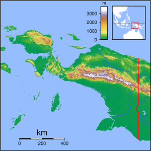  | |
| Date | August 1, 1989 |
|---|---|
| Origin time |
23:17 UTC 9:17 AEST |
| Magnitude | 6.0 Mw |
| Epicenter | 4°30′40″S 139°01′19″E / 4.511°S 139.022°ECoordinates: 4°30′40″S 139°01′19″E / 4.511°S 139.022°E[1] |
| Type | Dip-slip |
| Areas affected | Indonesia |
| Max. intensity | VIII (Severe)[2] |
| Casualties |
120 dead 120 injured |
The 1989 West Papua earthquake struck West Papua, Indonesia – then Irian Jaya province – on August 1 with a moment magnitude of 6.0 and a maximum Mercalli intensity of VIII (Severe). Around 120 people were killed, mainly due to landslides and mudslides.
Details and relief
The West Papua earthquake struck at 9:17 local time[3] and measured Ms 5.7[4] and 6.0 on the moment magnitude scale.[5] Its epicenter was located 299 km (186 mi) south of Jayapura;[6] the earthquake reached as far as Wamena.[4] There were multiple aftershocks.[6]
The earthquake killed 120 people and left 120 injured;[4] all of the dead were recovered from the villages of Holuon, Pasema, and Soba.[3] Many of these deaths and injuries derived from landslides that covered two villages and disrupted sections of the Baliem River, practically flooding three villages[7] and depositing tons of mud.[3] One of these landslides was 200 m (660 ft) tall;[7] there were eleven in total.[8] A large portion of the dead consisted of Dhani tribesmen.[6]
Local authorities distributed food, blankets, clothing, and money to survivors. Helicopters supplied food and other relief supplies,[6] but they were slowed by cracks in the local airstrips. More than 25 survivors were treated for severe injuries and another 100 for less grave maladies.[3] Between two hundred and three-hundred people were evacuated in the aftermath of the tremor,[3][7] and 3,500 Hupla people were resettled at a lower altitude, thus moving them from their traditional settlements.[9]
Geology
The focal mechanism for the earthquake demonstrated reverse faulting.[4] The region around the epicenter has a history of powerful earthquakes. Between two earthquakes in 1976 and 1981, 1000 people died.[6] There have been large earthquakes in the region as recently as 2009[10] and 2010.[11]
References
- ↑ "Significant earthquake". National Geophysical Data Center. Retrieved 18 August 2013.
- ↑ USGS (December 1, 2008), EXPO-CAT Earthquake Catalog, Version 2007-12, United States Geological Survey
- 1 2 3 4 5 "Indonesian quake kills 90". The Hour. August 2, 1989.
- 1 2 3 4 "Significant Earthquakes of the World: 1989". United States Geological Survey. January 5, 2010. Retrieved August 1, 2013.
- ↑ "Today in Earthquake History: August 1". United States Geological Survey. October 2, 2012. Retrieved August 1, 2013.
- 1 2 3 4 5 "Indonesian quake death toll rises". Lodi News-Sentinel. August 3, 1989.
- 1 2 3 "Indonesia: Earthquake Aug 1989 UNDRO Information Report 1". ReliefWeb. August 4, 1989. Retrieved August 1, 2013.
- ↑ "Death Toll Rises to 97 in Indonesia Quake". Los Angeles Times. August 5, 1989.
- ↑ Tapol, pg. 22.
- ↑ "Indonesia earthquake kills at least 2, injures 35". CNN. January 4, 2009. Retrieved August 2, 2013.
- ↑ "Indonesian earthquake death toll climbs to 17". CNN. June 21, 2010. Retrieved August 2, 2013.
Sources
- Tapol Bulletin. Tapol, the British Campaign for the Release of Indonesian Political Prisoners (109–120). 1992.