28th Street (IRT Lexington Avenue Line)
28th Street   | |||||||||||
|---|---|---|---|---|---|---|---|---|---|---|---|
| New York City Subway rapid transit station | |||||||||||
|
Local 6 train arriving for downtown | |||||||||||
| Station statistics | |||||||||||
| Address |
East 28th Street & Park Avenue South New York, NY 10016 | ||||||||||
| Borough | Manhattan | ||||||||||
| Locale | Rose Hill, Kips Bay | ||||||||||
| Coordinates | 40°44′36″N 73°59′03″W / 40.74329°N 73.984165°WCoordinates: 40°44′36″N 73°59′03″W / 40.74329°N 73.984165°W | ||||||||||
| Division | A (IRT) | ||||||||||
| Line | IRT Lexington Avenue Line | ||||||||||
| Services |
4  (late nights) (late nights) 6  (all times) <6> (all times) <6> (weekdays until 8:45 p.m., peak direction) (weekdays until 8:45 p.m., peak direction) | ||||||||||
| Structure | Underground | ||||||||||
| Platforms | 2 side platforms | ||||||||||
| Tracks | 4 | ||||||||||
| Other information | |||||||||||
| Opened | October 27, 1904[1] | ||||||||||
| Wireless service |
 [2][3] [2][3] | ||||||||||
| Traffic | |||||||||||
| Passengers (2015) |
7,214,293[4]  1.5% 1.5% | ||||||||||
| Rank | 59 out of 422 | ||||||||||
| Station succession | |||||||||||
| Next north |
33rd Street: 4 6 <6> | ||||||||||
| Next south |
23rd Street: 4 6 <6> | ||||||||||
| |||||||||||
| |||||||||||
|
| |||||||||||
|
28th Street Subway Station (IRT) | |||||||||||
| MPS | New York City Subway System MPS | ||||||||||
| NRHP Reference # | 05000230[5] | ||||||||||
| Added to NRHP | March 30, 2005 | ||||||||||
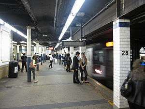
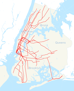


28th Street is a local station on the IRT Lexington Avenue Line of the New York City Subway. Located at Park Avenue South and 28th Street in Manhattan, it is served by the 6 train at all times, the <6> during weekdays in peak direction, and the 4 during late night hours.
History


Construction started on the first IRT line in 1900.[6] The part of the line from City Hall to just south of 42nd Street was part of the original IRT line, opened on October 27, 1904 including a local station at 28th Street.[1]
On April 13, 1948, the platform extensions to accommodate ten-car trains at this station along with those at 23rd Street, and 33rd Street were opened for use.[7]
Station layout
| G | Street Level | Exit/Entrance |
| P Platform level |
Side platform, doors will open on the right | |
| Northbound local | ← toward Pelham Bay Park ( toward Parkchester rush hours and middays) (33rd Street) ← toward Woodlawn late nights (33rd Street) | |
| Northbound express | ←  do not stop here do not stop here | |
| Southbound express | → do not stop here → | |
| Southbound local | → toward Brooklyn Bridge – City Hall ( toward New Lots Avenue late nights) (23rd Street) → | |
| Side platform, doors will open on the right | ||
This station contains four tracks and two side platforms. The two middle express tracks run at a lower level than the two outer local ones. The fare control is at platform level and there are no open crossunders or crossovers. However, there is a closed crossunder with railings and a blacked out sign indicating its location. The token booth is unusual in that it is built into the tile wall instead of a standalone structure like most other stations. The station's ornamentation includes glass block wall artwork at the main fare control entitled Seven Ways 4 Twenty-Eighth, which was installed during station renovations in 1996. There is also an unusual back-lit station sign name, similar to that at 23rd Street, at fare control.
The 28th Street station has been listed on the National Register of Historic Places since 2005.[8]
Under the 2015–2019 MTA Capital Plan, the station, along with thirty other New York City Subway stations, will undergo a complete overhaul and would be entirely closed for up to 6 months. Updates would include cellular service, Wi-Fi, charging stations, improved signage, and improved station lighting.[9][10]
Exits
| Exit location | Number of exits | Platform served |
|---|---|---|
| NW corner of Park Avenue S and 28th Street | 1 | Southbound |
| SW corner of Park Avenue S and 28th Street | 2 | Southbound |
| NE corner of Park Avenue S and 28th Street | 2 | Northbound |
| SE corner of Park Avenue S and 28th Street | 2 | Northbound |
| 372 Park Avenue South, between 26th and 27th Streets | 1 | Southbound (open 7am – 7pm) |
Image gallery
-
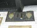
Plaque by Heins & LaFarge / Grueby Faience Company, 1904.
-
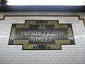
Faience name tablet by Heins & LaFarge / Grueby Faience Company, 1904.
-

Wall mosaic
-
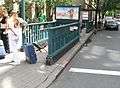
Northbound street stair
-
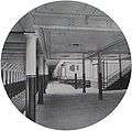
28th Street station in 1904
-
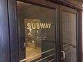
Downtown entrance within the New York Life Building
-
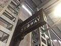
"Interborough Subway" sign outside the New York Life building
References
- 1 2 New York Times, Our Subway Open: 150,000 Try It, October 28, 1904
- ↑ "NYC Subway Wireless – Active Stations". Transit Wireless Wifi. Retrieved 2016-05-18.
- ↑ Attached PDF to "Governor Cuomo Announces Wireless Service and New "Transit Wireless WiFi" in Queens and Manhattan Subway Stations", governor.ny.gov
- ↑ "Facts and Figures: Annual Subway Ridership". Metropolitan Transportation Authority. Retrieved 2016-04-19.
- ↑ "NPS Focus". National Register of Historic Places. National Park Service. Retrieved December 24, 2011.
- ↑ "www.nycsubway.org". www.nycsubway.org.
- ↑ Report for the three and one-half years ending June 30, 1949. New York City Board of Transportation. 1949.
- ↑ New York County Listings at the National Register of Historic Places(Structure - #05000230)
- ↑ "MTA Will Completely Close 30 Subway Stations For Months-Long "Revamp"". Gothamist. Retrieved 2016-07-18.
- ↑ "MTAStations" (PDF). governor.ny.gov. Government of the State of New York. Retrieved 2016-07-18.
Further reading
- Lee Stokey. Subway Ceramics : A History and Iconography. 1994. ISBN 978-0-9635486-1-0
External links
 |
Wikimedia Commons has media related to 28th Street (IRT Lexington Avenue Line). |
- nycsubway.org – IRT East Side Line: 28th Street
- nycsubway.org – 7 waves 4 twenty eight Artwork by Gerald Marks (1996)
- Forgotten NY – Original 28 - NYC's First 28 Subway Stations
- 28th Street entrance from Google Maps Street View
- 26th-27th Streets entrance from Google Maps Street View
- Platforms from Google Maps Street View
| Topics |   | |
|---|---|---|
| Lists by county |
| |
| Lists by city | ||
| Other lists | ||
| ||

