Aban, Russia
| Aban (English) Абан (Russian) | |
|---|---|
|
- Rural locality[1] - Settlement[1] | |
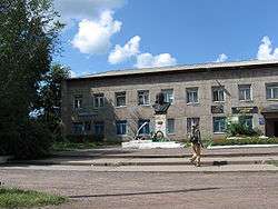 Bogutskogo Square (August 2009) | |
.svg.png) Location of Krasnoyarsk Krai in Russia | |
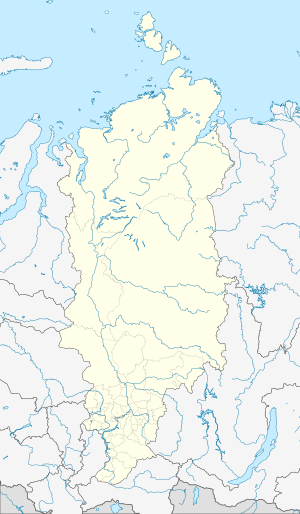  Aban | |
|
| |
| Administrative status (as of 2007) | |
| Country | Russia |
| Federal subject | Krasnoyarsk Krai |
| Administrative district | Abansky District[1] |
| Selsoviet | Abansky Selsoviet[1] |
| Administrative center of | Abansky District, Abansky Selsoviet |
| Municipal status (as of December 2008) | |
| Municipal district | Abansky Municipal District[2] |
| Rural settlement | Abansky Rural Settlement[2] |
| Administrative center of | Abansky Municipal District,[2] Abansky Rural Settlement[3] |
| Statistics | |
| Population (2010 Census) | 9,187 inhabitants[4] |
| Time zone | KRAT (UTC+07:00)[5] |
| First mentioned | 1762[6] |
| Rural locality status since | January 1, 2007[1] |
| Postal code(s)[7] | 663740 |
| Dialing code(s) | +7 39163[8] |
Aban (Russian: А́бан) is a rural locality (a settlement) and the administrative center of Abansky District of Krasnoyarsk Krai, Russia. Population: 9,187 (2010 Census);[4] 9,823 (2002 Census);[9] 10,382 (1989 Census).[10]
Geography
It is located on the Aban River, 62 kilometers (39 mi) northeast of Kansk-Yeniseysky railway station (on the Krasnoyarsk—Irkutsk line).
History
It was first mentioned in 1762.[6] It was granted urban-type settlement status in 1965[11] and held it until January 1, 2007, when it was demoted in status to that of a settlement of rural type.[1]
Economy
Coal output (the Abansky coal deposit). Logging, timber treatment, creamery, light industry enterprises.
Mars
The name Aban has been used for a crater on the planet Mars by the International Astronomical Union, although not specifically commemorating the village.[12]
References
Notes
- 1 2 3 4 5 6 Законодательное Собрание Красноярского края. Закон №21-5541 от 26 декабря 2006 г. «Об отнесении посёлка Абан Абанского района к категории сельских населённых пунктов». (Legislative Assembly of Krasnoyarsk Krai. Law #21-5541 of December 26, 2006 On Changing the Status of the Settlement of Aban of Abansky District to That of a Rural Inhabited Locality. ).
- 1 2 3 Law #13-2755, Article 1.2
- ↑ Law #13-2755, Article 2.3
- 1 2 Russian Federal State Statistics Service (2011). "Всероссийская перепись населения 2010 года. Том 1" [2010 All-Russian Population Census, vol. 1]. Всероссийская перепись населения 2010 года (2010 All-Russia Population Census) (in Russian). Federal State Statistics Service. Retrieved June 29, 2012.
- ↑ Правительство Российской Федерации. Федеральный закон №107-ФЗ от 3 июня 2011 г. «Об исчислении времени», в ред. Федерального закона №271-ФЗ от 03 июля 2016 г. «О внесении изменений в Федеральный закон "Об исчислении времени"». Вступил в силу по истечении шестидесяти дней после дня официального опубликования (6 августа 2011 г.). Опубликован: "Российская газета", №120, 6 июня 2011 г. (Government of the Russian Federation. Federal Law #107-FZ of June 31, 2011 On Calculating Time, as amended by the Federal Law #271-FZ of July 03, 2016 On Amending Federal Law "On Calculating Time". Effective as of after sixty days following the day of the official publication.).
- 1 2 The historical bulletin about area formation (Russian) Archived May 15, 2010, at the Wayback Machine.
- ↑ Russian Post. Aban (Russian)
- ↑ The directory of telephone codes (Russian) Archived March 4, 2012, at the Wayback Machine.
- ↑ Russian Federal State Statistics Service (May 21, 2004). "Численность населения России, субъектов Российской Федерации в составе федеральных округов, районов, городских поселений, сельских населённых пунктов – районных центров и сельских населённых пунктов с населением 3 тысячи и более человек" [Population of Russia, Its Federal Districts, Federal Subjects, Districts, Urban Localities, Rural Localities—Administrative Centers, and Rural Localities with Population of Over 3,000] (XLS). Всероссийская перепись населения 2002 года [All-Russia Population Census of 2002] (in Russian). Retrieved August 9, 2014.
- ↑ Demoscope Weekly (1989). "Всесоюзная перепись населения 1989 г. Численность наличного населения союзных и автономных республик, автономных областей и округов, краёв, областей, районов, городских поселений и сёл-райцентров" [All Union Population Census of 1989: Present Population of Union and Autonomous Republics, Autonomous Oblasts and Okrugs, Krais, Oblasts, Districts, Urban Settlements, and Villages Serving as District Administrative Centers]. Всесоюзная перепись населения 1989 года [All-Union Population Census of 1989] (in Russian). Институт демографии Национального исследовательского университета: Высшая школа экономики [Institute of Demography at the National Research University: Higher School of Economics]. Retrieved August 9, 2014.
- ↑ Исполнительный комитет Красноярского краевого Совета депутатов трудящихся. "Красноярский край. Административно-территориальное деление". Красноярское книжное издательство, Красноярск, 1972. Стр. 23
- ↑ Categories for Naming Features on Planets and Satellites, Gazetteer of Planetary Nomenclature, USGS Astrogeology Science Center, NASA
Sources
- Законодательное собрание Красноярского края. Закон №13-2755 от 17 декабря 2004 г. «Об установлении границ и наделении соответствующим статусом муниципального образования Абанский район и находящихся в его границах иных муниципальных образований», в ред. Закона №7-2509 от 4 декабря 2008 г «О внесении изменений в закон края "Об установлении границ и наделении соответствующим статусом муниципального образования Абанский район и находящихся в его границах иных муниципальных образований"». Вступил в силу через десять дней после официального опубликования. Опубликован: "Ведомости высших органов государственной власти Красноярского края", №1, 10 января 2005 г. (Legislative Assembly of Krasnoyarsk Krai. Law #13-2755 of December 17, 2004 On Establishing the Borders and Granting an Appropriate Status to the Municipal Formation of Abansky District and to Other Municipal Formations Within Its Borders, as amended by the Law #7-2509 of December 4, 2008 On Amending the Krai Law "On Establishing the Borders and Granting an Appropriate Status to the Municipal Formation of Abansky District and to Other Municipal Formations Within Its Borders". Effective as of ten days after the official publication.).