Alpestre, Rio Grande do Sul
| Alpestre | |||
|---|---|---|---|
| |||
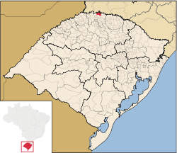 Location of Alpestre | |||
| Coordinates: 27°14′56″S 53°02′06″W / 27.24889°S 53.03500°WCoordinates: 27°14′56″S 53°02′06″W / 27.24889°S 53.03500°W | |||
| Country | Brazil | ||
| Region | South | ||
| State | Rio Grande do Sul | ||
| Founded | April 13, 1963 | ||
| Government | |||
| • Mayor | Valdir Jose Zasso (PDT) | ||
| Area | |||
| • Total | 328.749 km2 (126.931 sq mi) | ||
| Population (2008) | |||
| • Total | 9,017 | ||
| [1] | |||
| Time zone | UTC-3 (UTC-3) | ||
| • Summer (DST) | UTC-2 (UTC-2) | ||
| HDI (2000) | 0.714 – medium[2] | ||


Alpestre is the northernmost municipality in the state of Rio Grande do Sul, Brazil. The city lies near the Uruguay River, at its northernmost point. A landmark called Ponto Extremo Norto (Extreme North Point) marks the northernmost point of the state.
References
- ↑ IBGE 2008 statistics
- ↑ "Archived copy". Archived from the original on 2009-10-03. Retrieved 2009-12-17. - UNDP

This article is issued from Wikipedia - version of the 10/10/2016. The text is available under the Creative Commons Attribution/Share Alike but additional terms may apply for the media files.