Khuan Niang District
| Khuan Niang ควนเนียง | |
|---|---|
| Amphoe | |
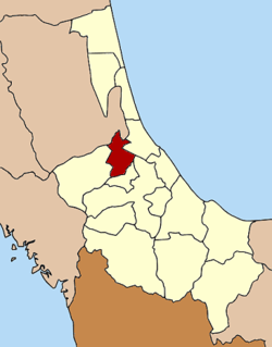 Amphoe location in Songkhla Province | |
| Coordinates: 7°11′13″N 100°21′28″E / 7.18694°N 100.35778°ECoordinates: 7°11′13″N 100°21′28″E / 7.18694°N 100.35778°E | |
| Country |
 Thailand Thailand |
| Province | Songkhla |
| Seat | Rattaphum |
| Area | |
| • Total | 208.0 km2 (80.3 sq mi) |
| Population (2005) | |
| • Total | 33,264 |
| • Density | 159.9/km2 (414/sq mi) |
| Time zone | THA (UTC+7) |
| Postal code | 90220 |
| Geocode | 9013 |
Khuan Niang (Thai: ควนเนียง) is a district (Amphoe) of Songkhla Province, southern Thailand.
History
The minor district (King Amphoe) was established on January 2, 1985 by splitting off four tambon from Rattaphum district.[1] It was upgraded to a full district on May 21, 1990.[2]
Geography
Neighboring districts are (from the east clockwise) Singhanakhon, Bang Klam and Rattaphum of Songkhla Province and Pak Phayun of Phatthalung Province.
Administration
The district is subdivided into 4 subdistricts (tambon), which are further subdivided into 46 villages (muban). Khuan Niang is a township (thesaban tambon) which covers parts of the tambon Rattaphum. There are further 4 Tambon administrative organizations (TAO).
| No. | Name | Thai name | Villages | Inh. | |
|---|---|---|---|---|---|
| 1. | Rattaphum | รัตภูมิ | 13 | 13,760 | |
| 2. | Khuan So | ควนโส | 11 | 5,647 | |
| 3. | Huai Luek | ห้วยลึก | 9 | 4,917 | |
| 4. | Bang Riang | บางเหรียง | 13 | 8,940 |
References
- ↑ ประกาศกระทรวงมหาดไทย เรื่อง แบ่งเขตท้องที่อำเภอรัตภูมิ จังหวัดสงขลา ตั้งเป็นกิ่งอำเภอควนเมือง (PDF). Royal Gazette (in Thai). 102 (1 ง): 32. January 1, 1985.
- ↑ พระราชกฤษฎีกาตั้งอำเภอห้วยผึ้ง อำเภอวังวิเศษ อำเภอคลองหาด อำเภอป่าบอน อำเภอหนองหญ้าปล้อง อำเภอวังโป่ง อำเภอควนเนียง อำเภอหนองหญ้าไซ อำเภอบ้านนาเดิม อำเภอทุ่งฝน อำเภอสร้างคอม และอำเภอทองแสนขัน พ.ศ. ๒๕๓๓ (PDF). Royal Gazette (in Thai). 107 (83 ก special): 1–4. May 21, 1994.
External links
This article is issued from Wikipedia - version of the 11/18/2014. The text is available under the Creative Commons Attribution/Share Alike but additional terms may apply for the media files.