Sap Yai District
| Sap Yai ซับใหญ่ | |
|---|---|
| Amphoe | |
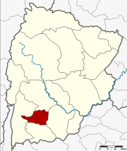 Amphoe location in Chaiyaphum Province | |
| Coordinates: 15°38′30″N 101°37′48″E / 15.64167°N 101.63000°ECoordinates: 15°38′30″N 101°37′48″E / 15.64167°N 101.63000°E | |
| Country |
 Thailand Thailand |
| Province | Chaiyaphum |
| Seat | Sap Yai |
| Area | |
| • Total | 171.0 km2 (66.0 sq mi) |
| Population (2005) | |
| • Total | 13,466 |
| • Density | 78.8/km2 (204/sq mi) |
| Time zone | THA (UTC+7) |
| Postal code | 36130 |
| Geocode | 3616 |
Sap Yai (Thai: ซับใหญ่) is a district (Amphoe) of Chaiyaphum Province, northeastern Thailand.
History
The minor district was separated from Chatturat district on July 1, 1997.[1]
Following a decision of the Thai government on May 15, 2007, all of the 81 minor districts were to be upgraded to full districts.[2] With the publishing in the Royal Gazette on August 24 the upgrade became official .[3]
Geography
Neighboring districts are (from the north clockwise) Nong Bua Rawe, Chatturat, Bamnet Narong and Thep Sathit.
Administration
The minor district is subdivided into 3 subdistricts (tambon), which are further subdivided into 33 villages (muban). There are no municipal (thesaban) areas, and 3 Tambon administrative organizations (TAO).
| No. | Name | Thai name | Villages | Inh. | |
|---|---|---|---|---|---|
| 1. | Sap Yai | ซับใหญ่ | 12 | 6,097 | |
| 2. | Tha Kup | ท่ากูบ | 11 | 4,177 | |
| 3. | Tako Thong | ตะโกทอง | 10 | 3,192 |
References
- ↑ ประกาศกระทรวงมหาดไทย เรื่อง แบ่งเขตท้องที่อำเภอจัตุรัส จังหวัดชัยภูมิ ตั้งเป็นกิ่งอำเภอซับใหญ่ (PDF). Royal Gazette (in Thai). 114 (Special 51 ง): 6. June 25, 1997.
- ↑ แถลงผลการประชุม ครม. ประจำวันที่ 15 พ.ค. 2550 (in Thai). Manager Online.
- ↑ พระราชกฤษฎีกาตั้งอำเภอฆ้องชัย...และอำเภอเหล่าเสือโก้ก พ.ศ. ๒๕๕๐ (PDF). Royal Gazette (in Thai). 124 (46 ก): 14–21. August 24, 2007.
External links
This article is issued from Wikipedia - version of the 11/18/2014. The text is available under the Creative Commons Attribution/Share Alike but additional terms may apply for the media files.