Annaba Province
| Annaba Province Holigans Annaba | |
|---|---|
| Province | |
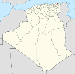 Map of Algeria highlighting Annaba | |
| Coordinates: 36°54′N 7°46′E / 36.900°N 7.767°ECoordinates: 36°54′N 7°46′E / 36.900°N 7.767°E | |
| Country |
 Algeria Algeria |
| Capital | Annaba |
| Area | |
| • Total | 1,439 km2 (556 sq mi) |
| Population (2008)[1] | |
| • Total | 640,050 |
| • Density | 440/km2 (1,200/sq mi) |
| Time zone | CET (UTC+01) |
| Area Code | +213 (0) 38 |
| ISO 3166 code | DZ-23 |
| Districts | 6 |
| Municipalities | 12 |
Annaba (Arabic: ولاية عنابة) is a small province (wilaya) in the north-eastern corner of Algeria. Its capital, Annaba is Algeria's main port for mineral exports.
Administrative divisions
The province is divided into 6 districts and 12 municipalities.[2]
The districts are:
- Annaba
- Aïn El Berda
- El Hadjar
- Berrahal
- Chetaïbi
- El Bouni
The municipalities are:
References
- ↑ Office National des Statistiques, Recensement General de la Population et de l’Habitat 2008 Preliminary results of the 2008 population census. Accessed on 2008-07-02.
- ↑ "The official journal of People's Democratic Republic of Algeria" (PDF). SGG Algeria. Retrieved 2007-11-06.
External links
| Annaba District |  | |
|---|---|---|
| Aïn El Berda District |
| |
| El Hadjar District | ||
| Berrahal District | ||
| Chetaïbi District | ||
| El Bouni District | ||
| | |
This article is issued from Wikipedia - version of the 3/11/2016. The text is available under the Creative Commons Attribution/Share Alike but additional terms may apply for the media files.