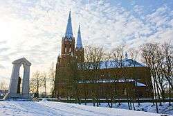
Anykščiai District Municipality
| Anykščiai District Municipality Anykščių rajono savivaldybė | ||
|---|---|---|
| Municipality | ||
 | ||
| ||
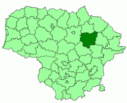 Location of Anykščiai district municipality within Lithuania | ||
| Coordinates: 55°32′11″N 25°6′38″E / 55.53639°N 25.11056°ECoordinates: 55°32′11″N 25°6′38″E / 55.53639°N 25.11056°E | ||
| Country |
 Lithuania Lithuania | |
| Ethnographic region | Aukštaitija | |
| County |
 Utena County Utena County | |
| Capital | Anykščiai | |
| Elderships | 10 | |
| Area | ||
| • Total | 1,765 km2 (681 sq mi) | |
| Area rank | 6th | |
| Population (2001 census) | ||
| • Total | 35,100 | |
| • Rank | 35th | |
| • Density | 20/km2 (52/sq mi) | |
| • Density rank | 53rd | |
| Time zone | EET (UTC+2) | |
| • Summer (DST) | EEST (UTC+3) | |
| Telephone code | 381 | |
| Major settlements | ||
| Website |
www | |

Anykščiai District Municipality is one of 60 municipalities in Lithuania.
Structure
District structure:
- 3 cities – Anykščiai, Kavarskas and Troškūnai;
- 8 towns – Andrioniškis, Debeikiai, Kurkliai, Skiemonys, Surdegis, Svėdasai, Traupis and Viešintos;
- 758 villages.
Biggest population (2001):
- Anykščiai – 11958
- Svėdasai – 1002
- Kavarskas – 809
- Naujieji Elmininkai – 696
- Troškūnai – 525
- Kurkliai – 474
- Ažuožeriai – 452
- Debeikiai – 452
- Aknystos – 441
- Raguvėlė – 398
| Municipalities |  | |
|---|---|---|
| Cities | ||
| Towns | ||
| Villages | ||
This article is issued from Wikipedia - version of the 5/14/2016. The text is available under the Creative Commons Attribution/Share Alike but additional terms may apply for the media files.