Arapahoe Acres
|
Arapahoe Acres | |
 | |
   | |
| Nearest city | Englewood, Arapahoe County, Colorado |
|---|---|
| Coordinates | 39°39′44″N 104°58′13″W / 39.66222°N 104.97028°WCoordinates: 39°39′44″N 104°58′13″W / 39.66222°N 104.97028°W |
| Area | 30 acres (12 ha) |
| Architect | Eugene Sternberg, Joseph Dion |
| Architectural style | International and Usonian |
| NRHP Reference # | 98001249[1] |
| CSRHP # | 5AH.1434 |
| Added to NRHP | November 3, 1998 |
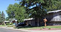
Arapahoe Acres is a neighborhood bounded by East Bates & East Dartmouth Avenues, and South Marion & South Franklin Streets in Englewood, Colorado. Built from 1949 to 1957 it provides great samples of new patterns developed for residential neighborhoods after World War II.
See also
- National Register of Historic Places listings in Arapahoe County, Colorado
- Website
- Blog
- 117 Photos of Arapahoe Acres
- Diane Wray's Book The Arapahoe Acres Historic District
References
- ↑ National Park Service (2010-07-09). "National Register Information System". National Register of Historic Places. National Park Service.
External links
| Topics | |
|---|---|
| Lists by states |
|
| Lists by insular areas | |
| Lists by associated states | |
| Other areas | |
| |


This article is issued from Wikipedia - version of the 11/28/2016. The text is available under the Creative Commons Attribution/Share Alike but additional terms may apply for the media files.