Arkansas Highway 282
| ||||
|---|---|---|---|---|
 | ||||
| Route information | ||||
| Maintained by AHTD | ||||
| Length: | 19.48 mi[1] (31.35 km) | |||
| Major junctions | ||||
| South end: |
.svg.png) US 64 east of Van Buren US 64 east of Van Buren | |||
 I-49 – Rudy I-49 – Rudy.svg.png) US 71 – Dean's Market US 71 – Mountainburg I-49 – Chester US 71 – Dean's Market US 71 – Mountainburg I-49 – Chester | ||||
| North end: | Brown St., Chester | |||
| Location | ||||
| Counties: | Crawford | |||
| Highway system | ||||
| ||||


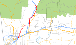
Arkansas Highway 282 is a north–south state highway in Crawford County. The route runs 19.48 miles (31.35 km) north from Van Buren to Chester.[1] The route parallels Interstate 49 for almost its entire length.
Route description
AR 282 begins at US 64 east of Van Buren. The route crosses I-40/I-49/US 71 (no interchange) east of Van Buren before turning north towards Rudy. AR 282 concurs with AR 348 in Rudy before turning east to cross I-49 again. The route continues east to Dean's Market, running north briefly with US 71/AR 162/AR 348. The route continues due north alone, crossing and then crossing back over I-49. AR 282 meets US 71 again in Mountainburg before again crossing I-49 to Chester. In Chester, AR 282 terminates at Brown Street.
Major intersections
The entire route is in Crawford County.
| Location | mi[1] | km | Destinations | Notes | |
|---|---|---|---|---|---|
| Van Buren | 0.0 | 0.0 | US 64 (Alma Hwy) | Southern terminus | |
| | 1.57 | 2.53 |  AR 60 east AR 60 east | AR 60 eastern terminus | |
| | 6.50 | 10.46 | AR 60 north | AR 60 southern terminus | |
| | 9.45 | 15.21 | I-49 – Fort Smith, Fayetteville | ||
| | 10.13 | 16.30 | US 71 south | ||
| US 71 concurrency north, 0.7 miles (1.1 km) | |||||
| | 0.0 | 0.0 | US 71 north | ||
| | 5.99 | 9.64 |  AR 282S north AR 282S north | AR 282S southern terminus | |
| Mountainburg | 7.52 | 12.10 | US 71 south | ||
| US 71 concurrency north, 3.2 miles (5.1 km) | |||||
| | 0.0 | 0.0 | US 71 north | ||
| | 1.01 | 1.63 | I-49 – Fayetteville, Ft Smith | ||
| Chester | 1.83 | 2.95 | Brown St | Northern terminus | |
1.000 mi = 1.609 km; 1.000 km = 0.621 mi
| |||||
Spur route
| |
|---|---|
| Location: | Mountainburg |
| Length: | 0.97 mi (1.56 km) |
| Existed: | 2010–present |
Arkansas Highway 282 Spur is a spur route of 0.97 miles (1.56 km) near Mountainburg. The route connects AR 282 over Interstate 49 to the local Arkansas State Highway and Transportation Department shop.[1]
References
- 1 2 3 4 Route and Section Map - Crawford County, Arkansas (PDF) (Map). Arkansas State Highway and Transportation Department. Retrieved May 26, 2011.