Arkansas Highway 299
| ||||
|---|---|---|---|---|
 | ||||
| Route information | ||||
| Maintained by AHTD | ||||
| Length: | 26.40 mi[1] (42.49 km) | |||
| Major junctions | ||||
| South end: |
 I-30 I-30 | |||
.svg.png) US 67, Emmet US 67, Emmet AR 53 AR 53.svg.png) US 371 US 371 | ||||
| East end: |
 AR 24, White Oak Lake State Park AR 24, White Oak Lake State Park | |||
| Location | ||||
| Counties: | Hempstead, Nevada | |||
| Highway system | ||||
| ||||


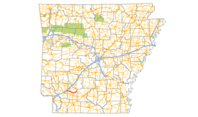
Highway 299 (AR 299, Ark. 299, and Hwy. 299) is a north–south state highway in Arkansas. The route of 26.40 miles (42.49 km) runs from Interstate 30 to AR 24 in White Oak Lake State Park.[2] The route is two–lane, undivided.[1]
Route description
Highway 299 begins at Interstate 30 in Hemsptead County.[3] The route runs south to intersect Highway 174 before turning east toward Emmet. In Emmet the route has a 0.1 miles (0.16 km) overlap with US 67 before continuing east into Nevada County. The route has a short concurrency with Highway 53 and then US 371 near Laneburg. East of this overlap the route serves as a terminus for Highway 372 and later Highway 200 before entering White Oak Lake State Park. After an intersection with Highway 387 the route terminates at Highway 24.[2] The route was most recently paved when a segment in Nevada County was resurfaced 1975, with all portions last receiving paving prior to that project.[1]
Major intersections
| County | Location | mi[1] | km | Destinations | Notes |
|---|---|---|---|---|---|
| Hempstead | | 0.00 | 0.00 | I-30 – Little Rock, Texarkana | Southern terminus |
| | 0.50 | 0.80 |  AR 174 west AR 174 west | ||
| Nevada | Emmet | 3.42 | 5.50 | US 67 (1st Street) | |
| US 67 concurrency north, 0.1 miles (0.16 km) |
|||||
| 0.00 | 0.00 | US 67 (1st Street) | |||
| | 6.83 | 10.99 | AR 53 south | ||
| AR 53 concurrency north, 0.3 miles (0.48 km) |
|||||
| US 371 concurrency south, 0.9 miles (1.4 km) |
|||||
| | 0.00 | 0.00 | US 371 south | ||
| | 4.31 | 6.94 |  AR 372 west AR 372 west | ||
| | 6.73 | 10.83 |  AR 200 west AR 200 west | ||
| White Oak Lake State Park | 16.07 | 25.86 |  AR 387 south AR 387 south | ||
| 16.15 | 25.99 | AR 24 south | Northern terminus | ||
1.000 mi = 1.609 km; 1.000 km = 0.621 mi
| |||||
History
The portions from Emmet-Highway 53 and from Highway 24-White Oak Lake State Park (at the time the Arkansas State Nursery) were added to the state highway system on April 24, 1963.[4] The discontinuous segments were connected on June 23, 1965.[5]
See also
-
 Arkansas portal
 -
 U.S. Roads portal
References
- 1 2 3 4 Planning and Research Division (2010). "Arkansas Road Log Database". Arkansas State Highway and Transportation Department. Archived from the original (Database) on 23 June 2011. Retrieved June 9, 2011.
- 1 2 General Highway Map (PDF) (Map) (Navada County ed.). Arkansas State Highway and Transportation Department. Archived (PDF) from the original on 18 July 2011. Retrieved August 9, 2011.
- ↑ General Highway Map (PDF) (Map) (Hempstead County ed.). Arkansas State Highway and Transportation Department. Archived (PDF) from the original on 18 July 2011. Retrieved August 9, 2011.
- ↑ "Minute Order 5013" (PDF). Minutes of the Meeting. Arkansas State Highway Commission. April 24, 1963. p. 917. Retrieved November 18, 2016.
- ↑ "Minute Order 65-190" (PDF). Minutes of the Meeting. Arkansas State Highway Commission. June 23, 1965. p. 667. Retrieved November 18, 2016.