Baker Canyon Fire
| Baker Canyon Fire | |
|---|---|
|
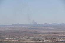
View of smoke from the fire as seen in Phoenix, over two hundred miles away | |
| Location | Northeast of Douglas, Arizona |
| Coordinates | 31°24′14″N 109°04′48″W / 31.404°N 109.08°W |
| Statistics[1] | |
| Date(s) | March 21, 2016 – March 28, 2016 |
| Burned area | 7,980 acres (32 km2) |
| Map | |
  Location of fire in Arizona | |
The Baker Canyon Fire was wildfire that began on March 3, 2016 northeast of Douglas, Arizona.[1] By the time the fire was contained it had burned 7,980 acres (32.3 km2) of land in both Arizona and New Mexico.[2]
References
- 1 2 "Baker Canyon Fire". InciWeb. Retrieved 31 August 2016.
- ↑ Reyes, Anthony Victor (28 March 2016). "Baker Canyon Fire grows to 7,980 acres, 90 percent contained". KVOA. Retrieved 30 March 2016.
This article is issued from Wikipedia - version of the 8/31/2016. The text is available under the Creative Commons Attribution/Share Alike but additional terms may apply for the media files.