Bethel Seaplane Base
| Bethel Seaplane Base | |||||||||||
|---|---|---|---|---|---|---|---|---|---|---|---|
 | |||||||||||
| IATA: JBT – ICAO: none – FAA LID: Z59 | |||||||||||
| Summary | |||||||||||
| Airport type | Public | ||||||||||
| Owner | Public Domain | ||||||||||
| Serves | Bethel, Alaska | ||||||||||
| Elevation AMSL | 15 ft / 5 m | ||||||||||
| Coordinates | 60°46′55″N 161°44′35″W / 60.78194°N 161.74306°W | ||||||||||
| Runways | |||||||||||
| |||||||||||
| Statistics | |||||||||||
| |||||||||||
Bethel Seaplane Base (IATA: JBT[2], FAA LID: Z59) is a public use seaplane base located on the Kuskokwim River in Bethel,[1] a city in the Bethel Census Area of the U.S. state of Alaska.
The state-owned Bethel Airport is located three nautical miles (5 km) west of this seaplane base.[3] Five nautical miles (9 km) to the south, also on the Kuskokwim River, is the Napaskiak Airport.[4]
Facilities
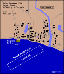
Bethel Seaplane Base has one waterway designated NE/SW which measures 3,000 by 500 feet (914 x 152 m). The facility is unattended. There are 15 single-engine aircraft based at this airport.[1]
References
- 1 2 3 FAA Airport Master Record for Z59 (Form 5010 PDF). Federal Aviation Administration. Effective 22 October 2009.
- ↑ Airport information for JBT at Great Circle Mapper. . Accessed 21 November 2009.
- ↑ Distance and heading from Bethel Seaplane Base (JBT) to Bethel Airport (BET). Great Circle Mapper. Accessed 21 November 2009.
- ↑ Distance and heading from Bethel Seaplane Base (JBT) to Napaskiak Airport (PKA). Great Circle Mapper. Accessed 21 November 2009.
External links
- FAA Alaska airport diagram (GIF)
- Resources for this airport:
- FAA airport information for Z59
- AirNav airport information for Z59
- ASN accident history for JBT
- FlightAware airport information and live flight tracker
- SkyVector aeronautical chart for Z59

This article is issued from Wikipedia - version of the 3/20/2013. The text is available under the Creative Commons Attribution/Share Alike but additional terms may apply for the media files.