Blair Precinct, Randolph County, Illinois
| Blair Precinct | |
|---|---|
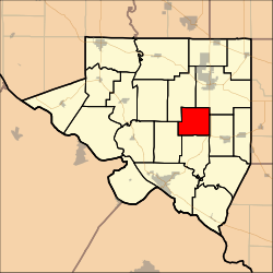 Location in Randolph County | |
| Coordinates: 38°02′39″N 089°44′33″W / 38.04417°N 89.74250°WCoordinates: 38°02′39″N 089°44′33″W / 38.04417°N 89.74250°W | |
| Country | United States |
| State | Illinois |
| County | Randolph |
| Area | |
| • Total | 17.52 sq mi (45.38 km2) |
| • Land | 17.44 sq mi (45.18 km2) |
| • Water | 0.08 sq mi (0.20 km2) 0.004% |
| Elevation | 512 ft (156 m) |
| Population (2000) | |
| • Total | 290 |
| • Density | 16.6/sq mi (6.42/km2) |
| GNIS feature ID | 1928447[1] |
Blair Precinct was a district of Randolph County, Illinois, USA. As of the 2000 census, its population was 290.[2] As of the 2010 census, it had been split between Central Precinct and Palestine Precinct.
Geography
Blair Precinct covered an area of 45.38 square kilometres (17.52 sq mi).
References
- ↑ "US Board on Geographic Names". United States Geological Survey. 2007-10-25. Retrieved 2008-01-31.
- ↑ "American FactFinder". United States Census Bureau. Archived from the original on 2013-09-11. Retrieved 2008-01-31.
Municipalities and communities of Randolph County, Illinois, United States | ||
|---|---|---|
| Cities |  | |
| Villages | ||
| Precincts | ||
| Unincorporated communities | ||
This article is issued from Wikipedia - version of the 11/3/2016. The text is available under the Creative Commons Attribution/Share Alike but additional terms may apply for the media files.