Blinnenhorn
| Blinnenhorn | |
|---|---|
| Corno Cieco | |
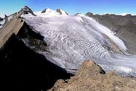 The north-east side of the Blinnenhorn with the Gries Glacier | |
| Highest point | |
| Elevation | 3,374 m (11,070 ft) |
| Prominence | 945 m (3,100 ft) [1] |
| Isolation | 12.8 km (8.0 mi) [2] |
| Parent peak | Dammastock |
| Coordinates | 46°25′33.4″N 8°18′28.9″E / 46.425944°N 8.308028°ECoordinates: 46°25′33.4″N 8°18′28.9″E / 46.425944°N 8.308028°E |
| Geography | |
  Blinnenhorn Location in the Alps | |
| Location | Valais, Switzerland/Piedmont, Italy |
| Parent range | Lepontine Alps |
| Climbing | |
| First ascent | 5 September 1866 by Sedley Taylor, Johann Tännler, and Franz Guntern (or Guntren)[3][4] |
The Blinnenhorn (German) or Corno Cieco (Italian) is a mountain in the Lepontine Alps, located on the border between Italy and Switzerland. On the north-east side lies the Gries Glacier.
See also
References
- ↑ Retrieved from the Swisstopo topographic maps. The key col is the Furka Pass (2,429)
- ↑ Retrieved from Google Earth. The nearest point of higher elevation is southeast of the Galmihorn.
- ↑ Summary of new ascents; Lepontine Alps, The Alpine Journal, December 1866
- ↑ F Gardiner, Excursions in the Lepontine Alps, The Alpine Journal, November 1878
External links
This article is issued from Wikipedia - version of the 10/21/2016. The text is available under the Creative Commons Attribution/Share Alike but additional terms may apply for the media files.