Boomerang Range
| Boomerang Range | |
|---|---|
 | |
| Highest point | |
| Elevation | ca. 1600m |
| Coordinates | 78°27′S 158°45′E / 78.45°S 158.75°ECoordinates: 78°27′S 158°45′E / 78.45°S 158.75°E |
| Geography | |
| Location | Boomerang Range, west side of Skelton Neve, Antarctica |
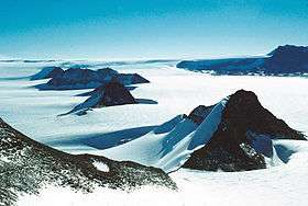
The Boomerang Range, (at 78°27′S 158°45′E / 78.45°S 158.75°E), is a narrow mountain range on the western side of the Skelton Glacier and Skelton Névé, Antarctica. The range is curved like a boomerang, and extends generally north-south for about 25 km. It was mapped and named in 1957 by geologists in the New Zealand party of the Commonwealth Trans-Antarctic Expedition (CTAE), 1956-58.[1][2]
References
This article is issued from Wikipedia - version of the 11/21/2015. The text is available under the Creative Commons Attribution/Share Alike but additional terms may apply for the media files.