Bowes Moor
| Bowes Moor | |
| Site of Special Scientific Interest | |
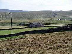 Bowes Moor | |
| Country | England |
|---|---|
| Region | North East |
| District | Teesdale |
| Location | NY923104 |
| - coordinates | 54°29′22″N 2°7′11″W / 54.48944°N 2.11972°WCoordinates: 54°29′22″N 2°7′11″W / 54.48944°N 2.11972°W |
| Area | 4,457.7 ha (11,015 acres) |
| Notification | 1989 |
| Management | Natural England |
| Area of Search | County Durham |
| Interest | Biological |
.png)  Location of Bowes Moor SSSI, Co Durham
| |
| Website: Map of site | |
Bowes Moor is a Site of Special Scientific Interest in the Teesdale district in south-west County Durham, England. It is an extensive area of moorland, most of it covered by blanket bog, which supports significant breeding populations of a number of wading birds.[1]
The Pennine Way National Trail passes through the area, as does the A66 road which crosses Bowes Moor using the Stainmore Gap between Bowes and Stainmore.
References
- ↑ "Bowes Moor" (PDF). English Nature. 1989. Retrieved 20 July 2010.
This article is issued from Wikipedia - version of the 7/11/2015. The text is available under the Creative Commons Attribution/Share Alike but additional terms may apply for the media files.