Cajatambo District
| Cajatambo Qaqatampu | |
|---|---|
| District | |
|
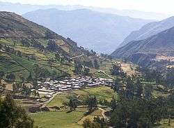
The village of Astobamba, Cajatambo District | |
| Country |
 Peru Peru |
| Region | Lima |
| Province | Cajatambo |
| Capital | Cajatambo |
| Government | |
| • Mayor | Miguel Angel Carlos Castillo |
| Area | |
| • Total | 567.96 km2 (219.29 sq mi) |
| Elevation | 3,376 m (11,076 ft) |
| Population (2005 census) | |
| • Total | 2,968 |
| • Density | 5.2/km2 (14/sq mi) |
| Time zone | PET (UTC-5) |
| UBIGEO | 150301 |
Cajatambo or Qaqatampu (Quechua) is one of five districts of the province Cajatambo in Peru.[1]
Geography
The Waywash mountain range traverses the district. Some of the highest peaks of the district are listed below:[2]
- Awkin
- Challwaqucha
- Chhanka
- Ichik Qayqu
- Millpu
- Misapata
- Mishi Waqanan
- Mit'u Punta
- Muntiqucha
- Parya Ukru
- Pishtaq
- Puka Qaqa
- Puka Qaqa (Mun.)
- Puskan T'urpu
- Phuyuq
- Qullqan
- Suyruqucha
- Shawanaqucha
- Waqshash
- Waylla Hirka
- Waylla Hirka (Caj.)
- Yana Kushman
- Yana Hirka
- Yana Paryan
- Yana Uqsha
- Yuraq Hirka
- Yuraq Qaqa
See also
References
- ↑ (Spanish) Instituto Nacional de Estadística e Informática. Banco de Información Distrital Archived April 23, 2008, at the Wayback Machine.. Retrieved April 11, 2008.
- ↑ escale.minedu.gob.pe UGEL map of the Cajatambo Province (Lima Region)
.svg.png)
Coordinates: 10°28′17″S 76°59′36″W / 10.4713°S 76.9933°W
This article is issued from Wikipedia - version of the 11/19/2016. The text is available under the Creative Commons Attribution/Share Alike but additional terms may apply for the media files.