Calbha Mor
Not to be confused with Calve Island.
| Gaelic name | Calbha Mor |
|---|---|
| Meaning of name | Large calf island[1] |
| Location | |
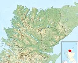  Calbha Mor Calbha Mor shown within Scotland | |
| OS grid reference | NC167367 |
| Physical geography | |
| Island group | Islands of Sutherland |
| Area | 70 ha[2] |
| Area rank | 174= [3] |
| Highest elevation | 67 metres (220 ft)[2] |
| Administration | |
| Sovereign state | United Kingdom |
| Country | Scotland |
| Council area | Highland |
| Demographics | |
| Population | Uninhabited |
 | |
Calbha Mor is a tidal islet in Eddrachillis Bay, Sutherland, Scotland.
Geography
Calbha Mor lies north of the Kylesku Bridge and west of the Duartmore forest in a location that is relatively inaccessible from the A894 road. It is 70 hectares (170 acres)[2] in extent and comprises two rounded hills, the highest of which reaches 67 metres (220 ft).[2]
It is separated from its smaller neighbour, Calbha Beag, by a channel 11 metres (36 ft) deep.[4] Calbha Beag is 45 hectares (110 acres) in area.[2]
The sheltered Bagh Calbha lies to the east and a large escape of fish from a fish farm here took place in 2003.[5]
Notes
- ↑ Mac an Tàilleir p. 25
- 1 2 3 4 5 Rick Livingstone’s Tables of the Islands of Scotland (pdf) Argyll Yacht Charters. Retrieved 12 Dec 2011.
- ↑ Area and population ranks: there are c. 300 islands over 20 ha in extent and 93 permanently inhabited islands were listed in the 2011 census.
- ↑ Calbha Mor Marine World Database. Retrieved 15 Dec 2011.
- ↑ "Mass escape of fake salmon in North West Sutherland" Steelheader Magazine. Retrieved 15 Dec 2011.
References
- Iain Mac an Tàilleir. "Placenames" (pdf). Pàrlamaid na h-Alba. Retrieved 23 July 2010.
Coordinates: 58°16′52″N 5°7′37″W / 58.28111°N 5.12694°W
This article is issued from Wikipedia - version of the 1/17/2016. The text is available under the Creative Commons Attribution/Share Alike but additional terms may apply for the media files.