Cape Santa Maria Airport
| Cape Santa Maria Airport | |||||||||||
|---|---|---|---|---|---|---|---|---|---|---|---|
| IATA: none – ICAO: MYLM | |||||||||||
| Summary | |||||||||||
| Airport type | Public | ||||||||||
| Serves | Cape Santa Maria | ||||||||||
| Location | Bahamas | ||||||||||
| Elevation AMSL | 5 ft / 2 m | ||||||||||
| Coordinates | 23°38′56.0″N 75°19′24.0″W / 23.648889°N 75.323333°WCoordinates: 23°38′56.0″N 75°19′24.0″W / 23.648889°N 75.323333°W | ||||||||||
| Map | |||||||||||
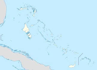  MYLM Location of Cape Santa Maria Airport in the Bahamas | |||||||||||
| Runways | |||||||||||
| |||||||||||
Cape Santa Maria Airport (ICAO: MYLM) is a public use airport located near Cape Santa Maria, the Bahamas.
The runway is currently closed and over grown. Do not try and land there.
See also
References
- ↑ Airport record for Cape Santa Maria Airport at Landings.com. Retrieved 2013-08-08
- ↑ Google (2013-08-08). "location of Cape Santa Maria Airport" (Map). Google Maps. Google. Retrieved 2013-08-08.
External links
- Airport record for Cape Santa Maria Airport at Landings.com
This article is issued from Wikipedia - version of the 11/8/2016. The text is available under the Creative Commons Attribution/Share Alike but additional terms may apply for the media files.