Capitol Hill, Saipan
| Capitol Hill | |
|---|---|
| Settlement | |
|
Commonwealth of the Northern Mariana Islands Legislature Building at Capitol Hill | |
| Territory | Northern Mariana Islands |
| Area | |
| • Total | 1.48 sq mi (3.8 km2) |
| Population (2010) | |
| • Total | 1,028[1] |
| Website | www.gov.mp |
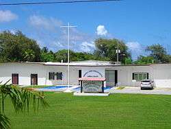
Capitol Hill[2][3][4] (sometimes spelled Capital Hill,[5] formerly Army Hill under the United States Navy[6]) is a settlement on the island of Saipan in the Northern Mariana Islands with a population of just over 1,000.[7] It has been the island group's capital since 1962. It lies on the cross-island road between Tanapag and San Vicente.
Capitol Hill was originally built in 1948 by the Central Intelligence Agency as a base involved in covert training of Nationalist Chinese guerrillas.[8]
The area is home to various government departments and agencies:
- Governor's Office
- Commonwealth of the Northern Mariana Islands Legislature Building
- US Post Office
- Commonwealth of the Northern Mariana Islands Department of Commerce
- Commonwealth of the Northern Mariana Islands Workforce Investment Agency
- Commonwealth of the Northern Mariana Islands Council for Arts and Culture
Transportation
Route 31 (Cross Island Road) or Isa Drive is the main road in the area.
Climate
References
- ↑ Haidee V. Eugenio. "Census: Garapan is most populous". Archived January 12, 2014, at the Wayback Machine. Saipan Tribune. 6 January 2012. Retrieved 10 January 2014.
- ↑ 1999 USGS map of Saipan
- ↑ U.S. Geological Survey Geographic Names Information System: Capitol Hill, Saipan
- ↑ USPS Post Office locations in Zip Code 96950
- ↑ U.S. Geological Survey Geographic Names Information System: Capitol Hill, Saipan
- ↑ Lal, Brij V.; Fortune, Kate (2000). The Pacific Islands: an encyclopedia. University of Hawaii Press. p. 104. ISBN 978-0-8248-2265-1.
- ↑ Haidee V. Eugenio. "Census: Garapan is most populous". Archived January 12, 2014, at the Wayback Machine. Saipan Tribune. 6 January 2012. Retrieved 10 January 2014.
- ↑ Bendure, G. & Friary, N. (1988). Micronesia:A travel survival kit. South Yarra, VIC: Lonely Planet. p. 194.
 |
Wikimedia Commons has media related to Capitol Hill, Saipan. |
Coordinates: 15°12′00″N 145°45′07″E / 15.2°N 145.751944°E
This article is issued from Wikipedia - version of the 11/18/2016. The text is available under the Creative Commons Attribution/Share Alike but additional terms may apply for the media files.