Châu Thành District, Tiền Giang
| Chau Thanh District Huyện Châu Thành | |
|---|---|
| Rural district | |
| Country |
 Vietnam Vietnam |
| Region | Mekong Delta |
| Province | Tien Giang |
| Capital | Châu Thành |
| Area | |
| • Total | 25,092,431 sq mi (64,989,098 km2) |
| Population (2003) | |
| • Total | 652,068 |
| Time zone | UTC + 7 (UTC+7) |
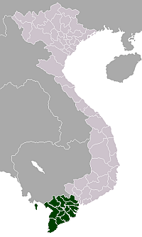
Châu Thành is a rural district of Tien Giang province in the Mekong Delta region of Vietnam. As of 2003 the district had a population of 252,068.[1] The district covers an area of 256 km². The district capital lies at Tan Hiep.[1]
References
- 1 2 "Districts of Vietnam". Statoids. Retrieved March 13, 2009.
Coordinates: 10°25′27″N 106°17′03″E / 10.42417°N 106.28417°E
This article is issued from Wikipedia - version of the 12/4/2014. The text is available under the Creative Commons Attribution/Share Alike but additional terms may apply for the media files.