Clocolan
| Clocolan | |
|---|---|
 | |
  Clocolan  Clocolan  Clocolan
| |
| Coordinates: 28°54′50″S 27°34′01″E / 28.91389°S 27.56694°ECoordinates: 28°54′50″S 27°34′01″E / 28.91389°S 27.56694°E | |
| Country | South Africa |
| Province | Free State |
| District | Thabo Mofutsanyane |
| Municipality | Setsoto |
| Established | 1907 |
| Area[1] | |
| • Total | 19.0 km2 (7.3 sq mi) |
| Population (2011)[1] | |
| • Total | 17,602 |
| • Density | 930/km2 (2,400/sq mi) |
| Racial makeup (2011)[1] | |
| • Black African | 95.7% |
| • Coloured | 0.3% |
| • Indian/Asian | 0.3% |
| • White | 3.6% |
| • Other | 0.1% |
| First languages (2011)[1] | |
| • Sotho | 86.4% |
| • English | 5.3% |
| • Afrikaans | 5.2% |
| • Sign language | 1.8% |
| • Other | 1.3% |
| Postal code (street) | 9735 |
| PO box | 9735 |
| Area code | 051 |
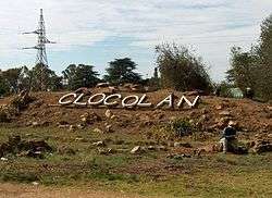
Clocolan, established in 1906, is a small town in the Free State province of South Africa. The Basotho called the place Hlohlolwane (Hlohla-o-lwane, "get up and fight"). New inhabitants mispronounced the name and called it Clocolan.
Town west of Prynn’s Berg, and some 166km north-east of Bloemfontein. Laid out on the farms Harold and Rienzi in 1906, it became a municipality in 1910. The name is of Sotho origin, said to be derived from hlohloloane, ‘bump and fight’, from an incident in which the bumping over of a basket filled with wheat led to a fight; or ‘pressed in the mountains’.[2]
References
- 1 2 3 4 Sum of the Main Places Hlohlolwane and Clocolan from Census 2011.
- ↑ "Dictionary of Southern African Place Names (Public Domain)". Human Science Research Council. p. 118.
 |
Winburg | Marquard | Rosendal | |
| Excelsior |  |
Ficksburg | ||
| ||||
 | ||||
| Tweespruit | Ladybrand Maseru |
Teyateyaneng |


Municipalities and communities of Thabo Mofutsanyana District Municipality, Free State | ||
|---|---|---|
District seat: Phuthaditjhaba (Witsieshoek) | ||
| Setsoto | .svg.png) | |
| Dihlabeng | ||
| Nketoana | ||
| Maluti-a-Phofung | ||
| Phumelela | ||
| Mantsopa | ||
This article is issued from Wikipedia - version of the 8/18/2016. The text is available under the Creative Commons Attribution/Share Alike but additional terms may apply for the media files.