Crag Hall
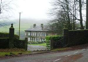
Crag Hall is a country house located to the east of the village of Wildboarclough, Cheshire, England. It was built in 1815 by George Palfreyman, the owner of a textile printing works nearby. It has since been extended by the addition of large curved bow windows at each end of the entrance front.[1] The house is constructed in brick-sized blocks of brown sandstone, with ashlar quoins and dressings. It is roofed in slate. The house is in two storeys.[2] The entrance front has five bays.[3] In the centre is a raised portico with four Ionic columns. It is approached from each side by a flight of steps. Its base is rusticated and contains three arched recesses.[2] Above the portico is a window with an entablature. About the house, Figueirdo and Treuherz comment that "it has an imposing air of millstone grit solidity".[1] The house is recorded in the National Heritage List for England as a designated Grade II* listed building.[2] Associated with the house are three structures listed at Grade II. These are the gateway with its wing walls,[4] the retaining wall to the garden terrace,[5] and a wall and summer house in the garden.[6]
See also
- Grade II* listed buildings in Cheshire East
- Listed buildings in Macclesfield Forest and Wildboarclough
References
- 1 2 de Figueiredo, Peter; Treuherz, Julian (1988), Cheshire Country Houses, Chichester: Phillimore, p. 226, ISBN 0-85033-655-4
- 1 2 3 Historic England, "Crag Hall (1329979)", National Heritage List for England, retrieved 25 September 2012
- ↑ Hartwell, Clare; Hyde, Matthew; Hubbard, Edward; Pevsner, Nikolaus (2011) [1971], Cheshire, The Buildings of England, New Haven and London: Yale University Press, p. 667, ISBN 978-0-300-17043-6
- ↑ Historic England, "Southwest gateway with gate piers and wing walls to Crag Hall (1145916)", National Heritage List for England, retrieved 25 September 2012
- ↑ Historic England, "Retaining wall to garden terrace of Crag Hall (1145915)", National Heritage List for England, retrieved 25 September 2012
- ↑ Historic England, "Wall and summerhouse at north end of garden at front of Crag Hall (1138900)", National Heritage List for England, retrieved 25 September 2012
Coordinates: 53°12′59″N 2°01′11″W / 53.21634°N 2.01960°W