Dennys River
| Dennys River | |
|---|---|
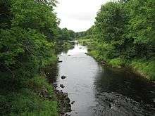 Dennys River from Bunker Hill Road in Dennysville | |
| Country | United States |
| Basin | |
| Main source | Maine |
| River mouth |
Hardscrabble River sea level 44°54′36″N 67°11′49″W / 44.910°N 67.197°WCoordinates: 44°54′36″N 67°11′49″W / 44.910°N 67.197°W |
| Physical characteristics | |
| Length | 23 miles (37 km) |
The Dennys River is a river in Washington County, Maine. From the outflow of Meddybemps Lake (45°02′20″N 67°21′27″W / 45.0390°N 67.3576°W) in Meddybemps, the river runs about 23 miles (37 km)[1] southeast and east to Dennysville, where it becomes tidal and soon joins the Hardscrabble River estuary to form Dennys Bay.
The Dennys River was named for an Indian hunter.[2]
See also
References
- ↑ U.S. Geological Survey. National Hydrography Dataset high-resolution flowline data. The National Map, accessed June 22, 2011
- ↑ Gannett, Henry (1905). The Origin of Certain Place Names in the United States. Govt. Print. Off. p. 104.
- "Dennys River". Geographic Names Information System. United States Geological Survey. 30 September 1980. Retrieved 2010-03-16.
- Maine Streamflow Data from the USGS
- Maine Watershed Data From Environmental Protection Agency
This article is issued from Wikipedia - version of the 10/14/2016. The text is available under the Creative Commons Attribution/Share Alike but additional terms may apply for the media files.