Donakonda Airport
| Donakonda Airport దొనకొండ విమానాశ్రయం Donakoṇḍa Vimānāśrayaṃ | |||||||||||
|---|---|---|---|---|---|---|---|---|---|---|---|
 | |||||||||||
| IATA: none – ICAO: VODK | |||||||||||
| Summary | |||||||||||
| Airport type | Public | ||||||||||
| Operator | Airports Authority of India | ||||||||||
| Location | Donakonda | ||||||||||
| Elevation AMSL | 467 ft / 142 m | ||||||||||
| Coordinates | 15°49′58.8″N 079°30′00″E / 15.833000°N 79.50000°ECoordinates: 15°49′58.8″N 079°30′00″E / 15.833000°N 79.50000°E | ||||||||||
| Runways | |||||||||||
| |||||||||||
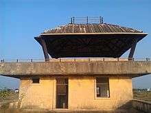
Donakonda Airport (ICAO: VODK) is located at Donakonda in Andhra Pradesh, India. The airfield was constructed during World War II by the British regime to refuel its aircraft.[1] It is owned by the Airports Authority of India and is closed.
Airlines and destinations
There is no scheduled commercial air service.
References
- ↑ "Debates take Donakonda turn". The Hindu. 21 March 2014. Retrieved 31 March 2014.
External links
 |
Wikimedia Commons has media related to Donakonda Airport. |
This article is issued from Wikipedia - version of the 11/29/2016. The text is available under the Creative Commons Attribution/Share Alike but additional terms may apply for the media files.