Downs Gulch Aerodrome
| Downs Gulch Aerodrome | |||||||||||
|---|---|---|---|---|---|---|---|---|---|---|---|
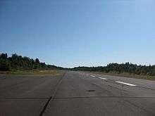 View along runway 05 of Downs Gulch Aerodrome from turn-around on northern edge | |||||||||||
| IATA: none – ICAO: none – TC LID: CDV2 | |||||||||||
| Summary | |||||||||||
| Airport type | Private | ||||||||||
| Owner | J.D. Irving | ||||||||||
| Operator | J.D. Irving Woodlands | ||||||||||
| Location | Downs Gulch, New Brunswick | ||||||||||
| Time zone | AST (UTC−04:00) | ||||||||||
| • Summer (DST) | ADT (UTC−03:00) | ||||||||||
| Elevation AMSL | 884 ft / 269 m | ||||||||||
| Coordinates | 47°45′11″N 067°25′36″W / 47.75306°N 67.42667°WCoordinates: 47°45′11″N 067°25′36″W / 47.75306°N 67.42667°W | ||||||||||
| Map | |||||||||||
  CDV2 Location in New Brunswick | |||||||||||
| Runways | |||||||||||
| |||||||||||
|
Source: Canada Flight Supplement[1] | |||||||||||
Downs Gulch Aerodrome (TC LID: CDV2), is a privately owned aerodrome located 7.5 nautical miles (13.9 km; 8.6 mi) north of Downs Gulch, New Brunswick, Canada. This aerodrome is near an area of the Restigouche River valley known for its good salmon fishing; consequently, many private and charter aircraft use this strip as a means of accessing nearby lodges in areas such as Larrys Gulch. There is no available parking for aircraft, only a wider turn-around area mid-runway, so all aircraft must depart after dropping off their passengers.
References
- ↑ Canada Flight Supplement. Effective 0901Z 15 September 2016 to 0901Z 10 November 2016
External links
- Page about this airport on COPA's Places to Fly airport directory
| By name | |
|---|---|
| By location indicator | |
| By province/territory | |
| By region | |
| National Airports System | |
| Related | |
| |


This article is issued from Wikipedia - version of the 12/4/2016. The text is available under the Creative Commons Attribution/Share Alike but additional terms may apply for the media files.