Durham, Queensland
| Durham Bulloo Shire, Queensland | |||||||||||||
|---|---|---|---|---|---|---|---|---|---|---|---|---|---|
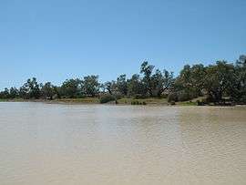 Bullah Bullah waterhole, 2008 | |||||||||||||
  Durham | |||||||||||||
| Coordinates | 27°15′31″S 141°47′35″E / 27.25861°S 141.79306°ECoordinates: 27°15′31″S 141°47′35″E / 27.25861°S 141.79306°E | ||||||||||||
| Population | 79 (2006)[1] | ||||||||||||
| LGA(s) | Bulloo Shire | ||||||||||||
| State electorate(s) | Warrego | ||||||||||||
| Federal Division(s) | Maranoa | ||||||||||||
| |||||||||||||
Durham is an outback locality in the Shire of Bulloo, Queensland, Australia.[2] In the 2006 census, Durham had a population of 79 people.[1]
Geography
Cooper Creek passes north-south through the centre of the locality.
Three major outback roads pass through Durham:[3]
- Adventure Way to South Australia
- Bullo Developmental Road to Cunnamulla
- Cooper Developmental Road to Quilpie
Attractions
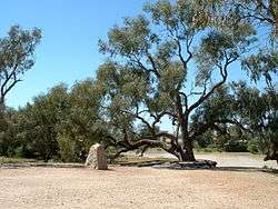
Burke and Wills dig tree, 2008
The heritage-listed Burke and Wills Dig Tree is located beside the Bullah Bullah Waterhole at the Nappa Merrie pastoral station (27°37′18″S 141°04′24″E / 27.6216°S 141.0734°E).[4]
References
- 1 2 Australian Bureau of Statistics (31 October 2012). "Duham (SSC)". 2011 Census QuickStats. Retrieved 16 May 2014.
- ↑ "Durham (entry 42967)". Queensland Place Names. Queensland Government. Retrieved 16 May 2014.
- ↑ "Downs South West Region West" (PDF). Road region maps. Queensland Government. Retrieved 17 May 2014.
- ↑ "Burke and Wills Dig Tree (entry 601073)". Queensland Heritage Register. Queensland Heritage Council. Retrieved 17 May 2014.
This article is issued from Wikipedia - version of the 7/13/2015. The text is available under the Creative Commons Attribution/Share Alike but additional terms may apply for the media files.