El Arish, Queensland
| El Arish Queensland | |||||||||||||
|---|---|---|---|---|---|---|---|---|---|---|---|---|---|
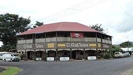 El Arish Tavern, 2016 | |||||||||||||
  El Arish | |||||||||||||
| Coordinates | 17°48′S 146°00′E / 17.800°S 146.000°ECoordinates: 17°48′S 146°00′E / 17.800°S 146.000°E | ||||||||||||
| Population | 442 (2011 census)[1] | ||||||||||||
| Postcode(s) | 4855 | ||||||||||||
| Elevation | 20 m (66 ft) | ||||||||||||
| Location |
| ||||||||||||
| LGA(s) | Cassowary Coast Region | ||||||||||||
| County | County of Nares | ||||||||||||
| Parish | Parish of Hull[2] | ||||||||||||
| State electorate(s) | Hinchinbrook | ||||||||||||
| Federal Division(s) | Kennedy | ||||||||||||
| |||||||||||||
| |||||||||||||
El Arish is a small town and locality in the Cassowary Coast Region of Queensland, Australia.[3][4] In the 2011 census, El Arish had a population of 442 people.[1]
History
The town is named after the city of Arish in Egypt where the Australian Light Horse saw action in December 1916 and which was later developed as a major base area with an allied hospital.[3][4]
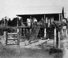
The town was founded in 1921 as a soldier settlement area. Many of the streets were named after high-ranking officers, including:[5]
- Chauvel Street after General Harry Chauvel
- Glasgow Street after Major General Thomas William Glasgow
- Monash Street after General John Monash
- Royston Street after Brigadier General John Royston
- Ryrie Street after Major General Granville Ryrie
And some were named after general veterans such as:
- Francis Martin Street after Francis Paxton Martin who set up some soldier settlements in El Arish in the 1920s.
The El Arish War Memorial is located on the south-west corner of Monash and Ryrie Streets (17°48′23″S 146°00′17″E / 17.806332°S 146.004821°E).[6]
The Maria Creek State School opened on 13 May 1922; it was renamed El Arish State School in 1925.[7][8]
El Arish Post Office opened by 1926 (a receiving office had been open from 1921).[9]
El Arish Tavern was established in 1927.[10]
The area was later settled by Italian Australians who worked in the sugar cane fields.
The town was hit by Severe Tropical Cyclone Yasi in February 2011.[11]
Heritage listings
Heritage-listed places in El Arish include:[10]
- the former El Arish railway station, now the" El Arish History Station, which houses a small soldier settlement and local history museum collection. There is a social morning tea held in the museum almost every Friday of the year at 9am, and visitors are more than welcome. We charge $2 as a donation.
- the El Arish Tavern
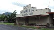
- the El Arish RSL Memorial Hall. We are very proud of the fact that we still have our hall, thanks to a long line of local volunteers since 1930.
Economy
Today, the area is home to a large sugar cane industry and banana plantations.[11]
Education
El Arish State School is a government primary (P-7) school located at 28 Chauvel Street (17°48′28″S 146°00′10″E / 17.80779°S 146.002822°E).[12]
Amenities

The El Arish Country Golf Club has a 9 hole course and is located on Golf Course Road (17°48′36″S 146°00′14″E / 17.81007°S 146.00377°E).[13]
Past population
At the 2006 census, El Arish had a population of 232.[14]
References
- 1 2 Australian Bureau of Statistics (31 October 2012). "El Arish (SSC)". 2011 Census QuickStats. Retrieved 25 May 2014.
- ↑ "Parish of Hull in the County of Nares". Brisbane: Survey Office. 1984. Retrieved 24 August 2016.
- 1 2 "El Arish (town) (entry 11421)". Queensland Place Names. Queensland Government. Retrieved 25 May 2014.
- 1 2 "El Arish (locality) (entry 45670)". Queensland Place Names. Queensland Government. Retrieved 25 May 2014.
- ↑ "El Arish". Destinations. Cassowary Coast Regional Council. Retrieved 26 May 2014.
- ↑ "El Arish War Memorial". Monument Australia. Retrieved 26 May 2014.
- ↑ "Opening and closing dates of Queensland Schools". Queensland Government. Retrieved 25 May 2014.
- ↑ "Agency ID5190, El Arish State School". Queensland State Archives. Retrieved 26 May 2014.
- ↑ Premier Postal History. "Post Office List". Premier Postal Auctions. Retrieved 10 May 2014.
- 1 2 "Local Heritage Places" (PDF). Cassowary Coast Regional Council. Archived (PDF) from the original on 24 August 2016. Retrieved 26 May 2014.
- 1 2 Koch, Tony (5 February 2011). "To El Arish, the worst in memory". The Australian. Retrieved 5 February 2011.
- ↑ "Queensland State and Non-State Schools". Queensland Government. Retrieved 25 May 2014.
- ↑ "El Arish Country Golf Club". World Golf. Retrieved 25 May 2014.
- ↑ Australian Bureau of Statistics (25 October 2007). "El Arish (L) (Urban Centre/Locality)". 2006 Census QuickStats. Retrieved 9 May 2011.

Further reading
- Rea, Malcolm M; Australia. Postmaster-General's Department (1967), El Arish, Public Relations Section, P.M.G.'s Dept
External links
 |
Wikimedia Commons has media related to El Arish, Queensland. |
- "El Arish". Queensland Places. Centre for the Government of Queensland, University of Queensland.