Erzincan Province
| Erzincan Province Erzincan ili | |
|---|---|
| Province of Turkey | |
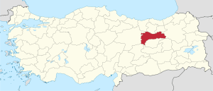 Location of Erzincan Province in Turkey | |
| Country | Turkey |
| Region | Northeast Anatolia |
| Subregion | Erzurum |
| Government | |
| • Electoral district | Erzincan |
| Area | |
| • Total | 11,974 km2 (4,623 sq mi) |
| Population (2010-12-31)[1] | |
| • Total | 224,949 |
| • Density | 19/km2 (49/sq mi) |
| • Urban | 114,437 |
| Area code(s) | 0446 |
| Vehicle registration | 24 |
Erzincan Province (Turkish: Erzincan ili) is a province in the eastern region of Anatolia, Turkey, and home to Erzincan, a city which was destroyed and rebuilt after an earthquake of magnitude 7.9 on December 27, 1939.[2] The population was 224,949 in 2010.
Geography
Erzincan is traversed by the northeasterly line of equal latitude and longitude.
Districts

Districts of Erzincan
Erzincan province is divided into 9 districts (capital district in bold):
See also
- 1939 Erzincan earthquake
- List of populated places in Erzincan Province
- Battle of Otlukbeli Martyrs' Monument
References
- ↑ Turkish Statistical Institute, MS Excel document – Population of province/district centers and towns/villages and population growth rate by provinces
- ↑ Rosie Ayliffe, Marc Dubin, John Gawthrop, Terry Richardson, Turkey, 1136 pp., Rough Guides, 2003, ISBN 1-84353-071-6, ISBN 978-1-84353-071-8 (see p.1016)
External links
 |
Wikimedia Commons has media related to Erzincan Province. |
- (Turkish) Erzincan governor's official website
- (Turkish) Erzincan municipality's official website
- (English) Erzincan weather forecast information
Coordinates: 39°40′42″N 39°19′48″E / 39.67833°N 39.33000°E
|  | |
Metropolitan municipalities are bolded. | ||

This article is issued from Wikipedia - version of the 9/20/2016. The text is available under the Creative Commons Attribution/Share Alike but additional terms may apply for the media files.