Gaurihar State
| Gaurihar State गौरिहार रियासत | |||||
| Princely State | |||||
| |||||
 | |||||
| History | |||||
| • | Established | 1807 | |||
| • | Accession to the Indian Union | 1950 | |||
| Area | |||||
| • | 1901 | 184 km2 (71 sq mi) | |||
| Population | |||||
| • | 1901 | 7,760 | |||
| Density | 42.2 /km2 (109.2 /sq mi) | ||||
| Malleson, G. B.: An historical sketch of the native states of India, London 1875, Reprint Delhi 1984 | |||||

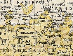
Gaurihar State was a princely state in India, ruling a territory that is now in Madhya Pradesh.[1] Gaurihar is a tehsil of Chhatarpur district.[2] The state has some famous and historical important monuments.
History
Gaurihar state was founded in 1807 after a split from Ajaigarh State. Maharaja Chandra Bhan Singh Ju Dev was the last ruler of Gaurihar state. He signed the accession to the Indian Union on 1 January 1950.[3]
Rulers
The rulers bore the title 'Sardar Sawai' and from 1859 the title 'Rao'.[4]
- 1807 - 1846 Raja Ram (d. 1846)
- 1846 - 1877 Rajdhar Rudra Pratap (b. 1811 - d. 18..)
- 1880 - 14 Nov 1887 Gajadhar Prasad (d. 1887)
- 1888 - 1904 Shamle Prasad (b. 1859 - d. 1904)
- 1904 - 1932 Pratipal (Prithvipal) Singh (b. 1886 - d. 19..)
- 1932 - 1947 Avadhendra Pratap Singh (b. 1902 - d. c.1970)
References
- ↑ Henige, David P. (2004). Princely states of India: a guide to chronology and rulers. Orchid Press. p. 67. ISBN 9789745240490.
- ↑ "Chhatarpur Tehsil Map, Chhatarpur Tehsil List". MapsofIndia.com. Retrieved 13 October 2013.
- ↑ Gaurihar Princely State
- ↑ Princely States of India A-J
External links
Coordinates: 25°17′44″N 80°10′29″E / 25.29556°N 80.17472°E
This article is issued from Wikipedia - version of the 9/21/2016. The text is available under the Creative Commons Attribution/Share Alike but additional terms may apply for the media files.