Gjerdinga
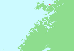 Location in Nord-Trøndelag | |
| Geography | |
|---|---|
| Location | Nord-Trøndelag, Norway |
| Coordinates | 64°57′06″N 11°25′46″E / 64.95168°N 11.42938°ECoordinates: 64°57′06″N 11°25′46″E / 64.95168°N 11.42938°E |
| Area | 5.5 km2 (2.1 sq mi) |
| Length | 3.6 km (2.24 mi) |
| Width | 2.4 km (1.49 mi) |
| Highest elevation | 117 m (384 ft) |
| Highest point | Øyrshatten |
| Administration | |
| County | Nord-Trøndelag |
| Municipality | Nærøy |
Gjerdinga is an island in the municipality of Nærøy in Nord-Trøndelag county, Norway. The island lies at the northern end of the Nærøysundet.[1] Most of the 20 residents of the island live in the village of Gjerdinga on the southeastern part of the island. The island is connected to the mainland by a ferry operated by Namsos Trafikkselskap. The ferry goes between Sæla (on the island) and Eidshaug (on Kvingra on the mainland) six times per day.
References
- ↑ "Gjerdinga" (in Norwegian). yr.no. Retrieved 2011-09-28.
This article is issued from Wikipedia - version of the 11/17/2016. The text is available under the Creative Commons Attribution/Share Alike but additional terms may apply for the media files.