Governor's Bridge (Patuxent River)
| Governor's Bridge | |
|---|---|
|
Governor's Bridge | |
| Coordinates | 38°57′05″N 76°41′36″W / 38.95139°N 76.69333°WCoordinates: 38°57′05″N 76°41′36″W / 38.95139°N 76.69333°W |
| Carries | Governor's Bridge Road |
| Crosses | Patuxent River |
| Owner | State Roads Commission |
| Heritage status |
Historic American Engineering Record,[1] Maryland Historical Trust[2] |
| Characteristics | |
| Design | Pratt truss[1] |
| Material | steel[1] |
| Total length | 105 feet 6 inches (32.16 m)[1] |
| Width | 13 feet 7 inches (4.14 m)[1] |
| History | |
| Constructed by | unknown[1] |
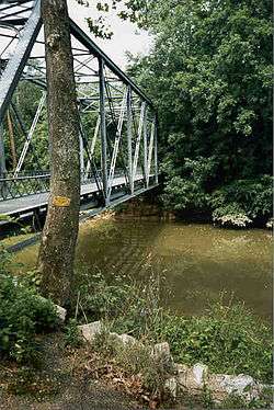
Governor's Bridge is an historic single-lane bridge over the Patuxent River near Bowie, Maryland. The river marks the boundary between Prince George's and Anne Arundel counties. A bridge has been located on this site since the mid-18th century.[1]
Although a common bridge type, the current Governor's Bridge is one of only two surviving truss bridges in Prince George's County.[1]
History
Three bridges have stood on this site.
The first bridge was constructed by Governor Samuel Ogle to travel between his mansion in Collington and the state capital in Annapolis.[2]
By 1817, the first bridge had been damaged beyond repair or destroyed and a ford was being used to traverse the river at the site.[3] On February 4, 1817, the State of Maryland commissioned Joseph N. Stockett and James Sanders of Anne Arundel County to build a new Governor's Bridge.[3]
Current bridge
The current truss bridge was constructed in 1912.[1]
The bridge was repaired in 2014 after structural deficiencies were discovered during a routine inspection.[4] It was closed in May 2013, underwent major repairs starting in January 2014, and reopened in March 2014.[5]
The bridge closed March 30, 2015, after contractors inspected the bridge and determined it required emergency repairs.[6] It is scheduled to reopen in 2019.[7]
See also
References
- 1 2 3 4 5 6 7 8 9 Lavoie, Catherine C. (1992). "Governor's Bridge" (PDF). Historic American Engineering Record. Washington, D.C.: Library of Congress. pp. 1–2. Retrieved 16 November 2015.
- 1 2 Maryland Historical Trust Property Number PG-74B-1 & AA-85I (PDF), Maryland Inventory of Historic Bridges, retrieved 5 January 2013
- 1 2 "162". Laws Made and Passed by the General Assembly of the State of Maryland: An act to provide for building Bridges over Patuxent River. State of Maryland. 1817. pp. 178–179.
- ↑ Pompi, Jenni (April 26, 2013). "Emergency Repairs Close Governor's Bridge Road Bridge: The bridge was temporarily closed by Prince George's County on Friday afternoon". Bowie Patch. Planck LLC d/b/a Patch Media. Retrieved March 21, 2014.
- ↑ "Governors Bridge Road Bridge Re-Opens" (Press release). Largo, Maryland: Prince George’s County Department of Public Works and Transportation (DPW&T). March 7, 2014. Retrieved March 21, 2014.
- ↑ Pratt, Tim (March 31, 2015). "Governor Bridge Road bridge closed over Patuxent River". Capital Gazette. Retrieved April 17, 2015.
- ↑ McNamara, John (13 April 2016). "Governor's Bridge won't re-open until 2019". The Capital. Retrieved 20 July 2016.
External links
- Historic American Engineering Record (HAER) No. MD-85, "Governor's Bridge, Governor's Bridge Road spanning Patuxent River, Bowie, Prince George's County, MD", 1 photo, 1 data page, 1 photo caption page