Großer Wannsee
| Großer Wannsee | |
|---|---|
 | |
 map | |
| Location | Berlin |
| Coordinates | 52°26′36″N 13°9′41″E / 52.44333°N 13.16139°ECoordinates: 52°26′36″N 13°9′41″E / 52.44333°N 13.16139°E |
| Primary inflows | Havel |
| Primary outflows | Havel |
| Basin countries | Germany |
| Surface area | 2.732 km2 (1.055 sq mi) |
| Max. depth | 9 m (30 ft) |
| Surface elevation | 32 m (105 ft) |
| Settlements | Berlin-Wannsee |
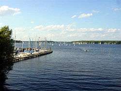
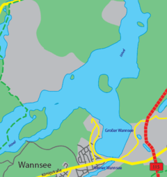
The Großer Wannsee (Greater Wannsee) is a bight of the Havel river near the locality of Wannsee and Nikolassee (in the borough of Steglitz-Zehlendorf), a south-western suburb of the German capital Berlin not far from Potsdam. Between the river itself and the Wannsee lies the Breite, or Grosse Breite (Broad, or Great Broad).[1] To the north lies the island of Schwanenwerder and, opposite from the Greater Wannsee on the other side of the Havel, is the locality of Kladow (in Spandau).[2]
Overview
The Wannsee lake is well known as the number-one bathing and recreation spot for western Berlin, especially from a 1951 Schlager hit by teen idol Cornelia Froboess. The Strandbad Wannsee, an open-air lido with one of the longest inland beaches in Europe and a popular nudist area, was built in 1920–30 after a concept by architect Richard Ermisch.[3] Situated on the eastern shore of the lake it is officially part of the Nikolassee locality.
Photogallery

 View of the lake from Wannsee railway station
 Sunset on the lake
See also
- Kleiner Wannsee (Little Wannsee)
- Pfaueninsel
- Griebnitzsee
References
- ↑ Grosser Berliner Stadtplan, 1961, Verlag Richard Schwarz Nachf.
- ↑ Source: "ADAC StadtAtlas - Berlin-Potsdam". ed. 2007 - pages 192, 193, 228, 229 - ISBN 3-8264-1348-2
- ↑ (German) Historical infos and pictures on www.strandbadwannsee.de
External links
 Media related to Großer Wannsee at Wikimedia Commons