Haga Haga
| Haga Haga | |
|---|---|
|
The view of Whale Point from Haga Haga | |
  Haga Haga  Haga Haga  Haga Haga
| |
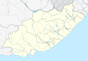
| Coordinates: 32°45′43″S 28°15′00″E / 32.762°S 28.250°ECoordinates: 32°45′43″S 28°15′00″E / 32.762°S 28.250°E | |
| Country | South Africa |
| Province | Eastern Cape |
| District | Amathole |
| Municipality | Great Kei |
| Area[1] | |
| • Total | 1.75 km2 (0.68 sq mi) |
| Population (2011)[1] | |
| • Total | 134 |
| • Density | 77/km2 (200/sq mi) |
| Racial makeup (2011)[1] | |
| • Black African | 40.3% |
| • Coloured | 0.7% |
| • White | 59.0% |
| First languages (2011)[1] | |
| • English | 51.1% |
| • Xhosa | 36.8% |
| • Afrikaans | 8.3% |
| • Zulu | 2.3% |
| • Other | 1.5% |
| PO box | 5272 |
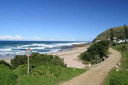
Haga Haga Eastern Cape Wild Coast of South Africa, 60 km east of East London.[2]
The village has been declared a conservancy owing to a number of rare indigenous species in the area, such as the Cape clawless otter and the blue duiker.[3]
References
- 1 2 3 4 "Main Place Haga Haga". Census 2011.
- ↑ "Haga Haga Accommodation and Activities". Wild Coast Holidays. Retrieved 10 October 2009.
- ↑ "Eastern Cape". Revealed.co.za. Retrieved 28 August 2014.
Municipalities and communities of Amathole District Municipality, Eastern Cape | ||
|---|---|---|
District seat: East London | ||
| Amahlathi | .svg.png) | |
| Great Kei | ||
| Mbhashe | ||
| Mnquma | ||
| Ngqushwa | ||
| Raymond Mhlaba | ||
This article is issued from Wikipedia - version of the 7/9/2016. The text is available under the Creative Commons Attribution/Share Alike but additional terms may apply for the media files.