Halsema Highway
| Halsema Highway | |
|---|---|
| |
|
Highest point marker in Atok, Benguet | |
| Route information | |
| Length: | 150.0 km (93.2 mi) |
| Major junctions | |
| North end: | Nueva Vizcaya–Ifugao–Mountain Province Road (in Bontoc) |
| South end: | Bokawkan Road (in Baguio) |
| Location | |
| Major cities: | Baguio |
| Towns: | |
| Highway system | |
| Highways in the Philippines | |
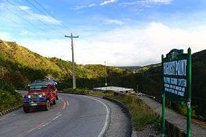
Halsema Highway (also known as the Benguet-Mountain Province Road, Baguio-Bontoc Road or Mountain Trail[1]) is a national highway in the Philippines. Situated within the Cordillera Central range in northern Luzon, it stretches from the city limit[2] of Baguio to the municipality of Bontoc.[3] At its highest point at 7,400 feet (2,300 m) above sea level in the municipality of Atok,[4] it is the highest altitude highway in the Philippines.[5]
The 150-kilometre (93.2 mi)[5] highway covers 95 kilometres (59 mi)[6] of Benguet province and traverses eight of its municipalities (La Trinidad, Tublay, Atok, Bokod, Kabayan, Buguias, Bakun, and Mankayan). It also covers four Mountain Province towns (Bauko, Sabangan, Bontoc, and Sagada).[7] The road splits into two upon reaching the village of Dantay, in Bontoc. One road leads to downtown Bontoc,[4] while the other leads to the town of Sagada, 29 kilometres (18.0 mi) farther from the junction.
History
The highway was named after an American engineer, named Eusebius Julius Halsema,[1][8] who served as the mayor of Baguio City from 1920-1937. Under Halsema's term, its construction commenced in 1922 with the help of locals and was completed in 1930 as a foot trail.
Hazards
Parts of the highway are dangerous, especially during the rainy season, when landslides are common and asphalted portions become slippery.[5][8]
In March 2013, List25 included the highway at #9 in its 25 Most Dangerous Roads in the World.[5][9]
References
- 1 2 Halsema, James. "History and Biography of Euseibus Julius Halsema". Halsema.org. Retrieved 29 September 2014.
- ↑ Aure Galacgac, Aure (6 February 2014). "Halsema Highway to be made 'tourist friendly'". Sun.Star Baguio. Retrieved 29 September 2014.
- ↑ Sy, Marvin (9 June 2010). "NEDA: Vegetable prices to rise during rainy season". The Philippine Star. Retrieved 30 September 2014.
- 1 2 Caluza, Desiree (26 May 2014). "Mountain Trail leads to culture, nature hubs". Philippine Daily Inquirer. Retrieved 30 September 2014.
- 1 2 3 4 "Halsema Highway". Dangerous Roads. Retrieved 29 September 2014.
- ↑ "Province of Benguet". Department of Interior and Local Government (Philippines) - Cordillera Administrative Region. DILG-CAR. 7 March 2013. Retrieved 30 September 2014.
- ↑ "Halsema Hway". Mapcentral. Retrieved 29 September 2014.
- 1 2 Glover, Morgan (27 July 2014). "Halsema Highway: Most Dangerous Driving Roads". Elephant Car Hire. Retrieved 29 September 2014.
- ↑ "25 Most Dangerous Roads in the World". List25. 11 March 2013. Retrieved 29 September 2014.
Coordinates: 16°34′30″N 120°44′11″E / 16.5750°N 120.7363°E