Haydon, Somerset
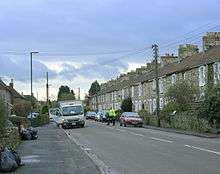
Haydon is a village lying between Radstock and Kilmersdon in Somerset, England. It is 1 mile (1.6 km) south-west of Radstock and 1.5 miles (2.4 km) north-east of Kilmersdon.
History
Haydon was built in the nineteenth century to house miners from the local pit in the Somerset Coalfield, which closed in 1973.[1][2]
The winding wheel from the pit is now displayed outside Radstock Museum.
Governance
Haydon forms part of the North East Somerset constituency, which elects a Member of Parliament to the House of Commons of the Parliament of the United Kingdom.[3] It is also part of the South West England constituency of the European Parliament.
Almost all significant local government functions are carried out by Bath and North East Somerset, a unitary authority.
References
 |
Wikimedia Commons has media related to Haydon, Somerset. |
- ↑ "Rural Areas — Area 15 Norton Radstock Southern Farmlands" (PDF). Bath and North East Somerset Council. pp. 74–76. Retrieved 10 January 2013.
- ↑ Sarah Westell (16 March 2012). "Kilmersdon Colliery, Haydon". My Bath and NE Somerset. Retrieved 15 August 2013.
- ↑ "Somerset North East: New Boundaries Calculation". Electoral Calculus: General Election Prediction. Retrieved 2007-09-19.
Coordinates: 51°16′59″N 2°27′04″W / 51.283°N 2.451°W