Helman Tor
| Helman Tor | |
|---|---|
| Torr Helman | |
 | |
| Highest point | |
| Elevation | 209 m (686 ft) |
| Coordinates | 50°25′19″N 4°43′46″W / 50.42194°N 4.72944°WCoordinates: 50°25′19″N 4°43′46″W / 50.42194°N 4.72944°W |
| Geography | |
| Location | Lanlivery, Cornwall, England, UK |
| OS grid | SX 062 615 |
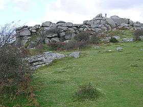
Helman Tor (Cornish: Torr Helman)[1] is a tor in mid Cornwall, England, UK. It is a nature reserve managed by the Cornwall Wildlife Trust. It is a County Geology Site and a Scheduled Ancient Monument.[2] It lies on the Saints' Way.[3] It is adjacent to Red Moor Site of Special Scientific Interest and Breney Common Special Area of Conservation.
It is the northern end of a granite ridge.[4] There is a logan stone or rocking stone on the site.

There is a prehistoric hill fort and a stone hut circle settlement on the site.[5] There is evidence of walls constructed in Neolithic period, around 6,000 years ago, as well as some level platforms, thought to be house sites, one platform has a network of postholes. There is also remains of a field system. These are similar to those at Carn Brea and limited excavation was carried out by Roger Mercer.[4]
References
- ↑ Place-names in the Standard Written Form (SWF) : List of place-names agreed by the MAGA Signage Panel. Cornish Language Partnership.
- ↑ "Helman Tor Nature Reserve (including Breney Common and Red Moor Memorial Nature Reserve)". Cornwall Wildlife Trust. 2012. Retrieved 20 October 2012.
- ↑ Ordnance Survey Landranger 200; Newquay, Bodmin & surrounding area, 1:50 000. 1988
- 1 2 "Helman Tor". Historic Environment Service, Cornwall Council. 7 May 2009. Retrieved 20 October 2012.
- ↑ "Earlier prehistoric hillfort, stone hut circle settlement and field system at Helman Tor". English Nature. Retrieved 20 October 2012.