Homebush, Queensland
| Homebush Queensland | |||||||||||||
|---|---|---|---|---|---|---|---|---|---|---|---|---|---|
  Homebush | |||||||||||||
| Coordinates | 21°16′17″S 149°02′51″E / 21.27139°S 149.04750°ECoordinates: 21°16′17″S 149°02′51″E / 21.27139°S 149.04750°E | ||||||||||||
| Population | 277 (2011 census)[1] | ||||||||||||
| Postcode(s) | 4740 | ||||||||||||
| Location |
| ||||||||||||
| LGA(s) | Mackay Region | ||||||||||||
| State electorate(s) | Mirani | ||||||||||||
| Federal Division(s) | Capricornia | ||||||||||||
| |||||||||||||
Homebush is a rural locality in Mackay Region, Queensland, Australia.[2] In the 2011 census, Homebush had a population of 277 people.[1]
History
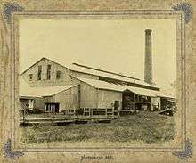
Homebush Sugar Mill, circa 1895
The name Homebush is taken from the name of a pastoral run name used by John Walker in 1866.[2]
Homebush Post Office opened on 5 December 1883 and closed in 1976.[3]
The Homebush Sugar Mill opened in 1883 and closed in 1922.[4]
Heritage listings
Homebush has a number of heritage-listed sites, including:
- Homebush Road: Homebush Mission Hall[5]
References
- 1 2 Australian Bureau of Statistics (31 October 2012). "Homebush". 2011 Census QuickStats. Retrieved 30 December 2015.
- 1 2 "Homebush (entry 46797)". Queensland Place Names. Queensland Government. Retrieved 13 September 2015.
- ↑ Premier Postal History. "Post Office List". Premier Postal Auctions. Retrieved 10 May 2014.
- ↑ "Homebush Sugar Mill, 1883-1922". www.mackayhistory.org. Retrieved 30 December 2015.
- ↑ "Homebush Mission Hall (entry 601705)". Queensland Heritage Register. Queensland Heritage Council. Retrieved 10 July 2013.
This article is issued from Wikipedia - version of the 12/30/2015. The text is available under the Creative Commons Attribution/Share Alike but additional terms may apply for the media files.