Hrastovica, Mokronog-Trebelno
| Hrastovica | |
|---|---|
|
Hrastovica from the west | |
  Hrastovica Location in Slovenia | |
| Coordinates: 45°57′59.12″N 15°9′2.05″E / 45.9664222°N 15.1505694°ECoordinates: 45°57′59.12″N 15°9′2.05″E / 45.9664222°N 15.1505694°E | |
| Country |
 Slovenia Slovenia |
| Traditional region | Lower Carniola |
| Statistical region | Southeast Slovenia |
| Municipality | Mokronog-Trebelno |
| Area | |
| • Total | 1.33 km2 (0.51 sq mi) |
| Elevation | 252.6 m (828.7 ft) |
| Population (2002) | |
| • Total | 113 |
| [1] | |
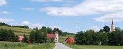
Hrastovica (pronounced [ˈxɾaːstɔʋitsa]) is a village north of Mokronog in the Municipality of Mokronog-Trebelno in southeastern Slovenia. It lies in the historical region of Lower Carniola. The municipality is now included in the Southeast Slovenia Statistical Region.[2]
Landmarks
The local church in the settlement is dedicated to Saint Roch and belongs to the Parish of Mokronog. It was built in 1661.[3] A single-arch stone bridge, built in the 19th century, leads across Jeseniščica Creek west of the church.[4] Zagorica Manor from the end of the 17th century or the beginning of the 18th century stands northeast of the church.[5]
References
- ↑ Statistical Office of the Republic of Slovenia
- ↑ Mokronog-Trebelno municipal website
- ↑ "EŠD 2058". Registry of Immovable Cultural Heritage (in Slovenian). Ministry of Culture of the Republic of Slovenia. Retrieved 10 May 2011.
- ↑ "EŠD 27195". Registry of Immovable Cultural Heritage (in Slovenian). Ministry of Culture of the Republic of Slovenia. Retrieved 21 September 2012.
- ↑ "EŠD 27143". Registry of Immovable Cultural Heritage (in Slovenian). Ministry of Culture of the Republic of Slovenia. Retrieved 21 September 2012.
External links
- Hrastovica at Geopedia
 Media related to Hrastovica, Mokronog–Trebelno at Wikimedia Commons

This article is issued from Wikipedia - version of the 8/2/2016. The text is available under the Creative Commons Attribution/Share Alike but additional terms may apply for the media files.