Huaraz District
| Huaraz Waras | |
|---|---|
| District | |
|
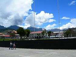
Main square in Huaraz with the Cordillera Blanca in the background | |
| Country |
 Peru Peru |
| Region | Ancash |
| Province | Huaraz |
| Capital | Huaraz |
| Government | |
| • Mayor | Vladimir Meza |
| Area | |
| • Total | 432.99 km2 (167.18 sq mi) |
| Elevation | 3,052 m (10,013 ft) |
| Population (2005 census) | |
| • Total | 52,592 |
| • Density | 120/km2 (310/sq mi) |
| Time zone | PET (UTC-5) |
| UBIGEO | 020101 |
Huaraz District is one of twelve districts of the province Huaraz in Peru.[1]
Geography
The Cordillera Blanca and the Cordillera Negra traverse the district. Some of the highest mountains of the district are listed below:[2]
- Antap'iti
- Kashan
- Kayish
- Kima Rumi
- Map'arahu
- Puka Hirka
- Qarwakancha
- Wamash Punta
- Wamashrahu
References
- ↑ (Spanish) Instituto Nacional de Estadística e Informática. Banco de Información Distrital. Retrieved April 11, 2008.
- ↑ escale.minedu.gob.pe - UGEL map of the Huaraz Province (Ancash Region)
| Aija | |
|---|---|
| Antonio Raymondi | |
| Asunción | |
| Bolognesi | |
| Carhuaz | |
| Carlos Fermín Fitzcarrald | |
| Casma | |
| Corongo | |
| Huaraz | |
| Huari | |
| Huarmey | |
| Huaylas | |
| Mariscal Luzuriaga | |
| Ocros | |
| Pallasca | |
| Pomabamba | |
| Recuay | |
| Santa | |
| Sihuas | |
| Yungay | |
.svg.png)
Coordinates: 9°32′S 77°32′W / 9.533°S 77.533°W
This article is issued from Wikipedia - version of the 6/1/2016. The text is available under the Creative Commons Attribution/Share Alike but additional terms may apply for the media files.