Interstate 369
| ||||
|---|---|---|---|---|
 | ||||
| Route information | ||||
| Maintained by TxDOT | ||||
| Length: | 3.5 mi[1] (5.6 km) | |||
| History: | Signed on September 23, 2013[2] | |||
| Texarkana area segment | ||||
| Length: | 3.5 mi[3] (5.6 km) | |||
| South end: |
  US 59 / SH 93 in Texarkana US 59 / SH 93 in Texarkana | |||
| North end: |
 I-30 / US 59 in Texarkana I-30 / US 59 in Texarkana | |||
| Highway system | ||||
| ||||


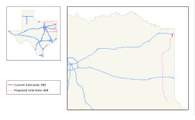
Interstate 369 (I-369) is a south–north Interstate spur route running through Northeast Texas. Once complete, the freeway will begin at an interchange with Interstate 69/U.S. Highway 84 east of Tenaha and head northward to Carthage, Marshall, Jefferson, and Atlanta before terminating at an interchange with I-49/US 59/US 71 north of Texarkana. For its entire length, I-369 will share its alignment with US 59.
History
At its November 15, 2012 meeting, the American Association of State Highway and Transportation Officials (AASHTO) approved a 118-mile-long (190 km) I-369, to connect I-69 in Tenaha to I-30 in Texarkana.[4] The Federal Highway Administration approved the designation on May 24, 2013,[5] and the Texas Transportation Commission followed suit on May 30, 2013.[6] This action also finalized the designations of other Interstates in Texas.[5] This action meant that the Texas Department of Transportation could commence the signing of I-369, as well as the other route segments cited, at their discretion. The signage was installed and revealed on September 23, 2013.[2]
Future
The status of the Texarkana to Tenaha segment is unfinished; it is currently only in the planning and development stage. The proposed route of I-369 is to go from Loop 151 in Texarkana, following US 59 to the junction of US 59/US 84/future I-69 in Tenaha. It may also be extended north from its current terminus at I-30 to a future interchange with Interstate 49 north of Texarkana.
Exit list
The entire route is in Texarkana, Bowie County. All exits are unnumbered.
| mi | km | Destinations | Notes | |||
|---|---|---|---|---|---|---|
| 0.0 | 0.0 |   .svg.png) US 59 south / SH 93 north (Lake Drive) / Loop 151 east / FM 3527 (Leopard Drive) to US 71 US 59 south / SH 93 north (Lake Drive) / Loop 151 east / FM 3527 (Leopard Drive) to US 71 | Southern end of US 59 concurrency; Continually south and east as Loop 151 and Texarkana Loop | |||
| 1.0 | 1.6 | Frontage Road | Southbound exit and northbound entrance | |||
| 1.5 | 2.4 |  US 67 (7th Street) US 67 (7th Street) | ||||
| 2.2 | 3.5 | Westlawn Drive – Wake Village | ||||
| 3.1 | 5.0 |  US 82 (New Boston Road) US 82 (New Boston Road) | ||||
| 3.6 | 5.8 |  FM 559 (Richmond Road) FM 559 (Richmond Road) | Northbound exit and southbound entrance | |||
| 3.8 | 6.1 | I-30 / US 59 north – Little Rock, Dallas | Northern end of US 59 concurrency; I-30 exit 220A | |||
| Gibson Lane | Proposed | |||||
| Mcknight Road | Proposed | |||||
| FM 559 (Richmond Road) | Proposed | |||||
| University Avenue | Proposed | |||||
  FM 1397 FM 1397 | Proposed | |||||
| CR 2320 (Hush Puppy Road) | Proposed | |||||
 I-49 – Ft. Smith, Shreveport I-49 – Ft. Smith, Shreveport | Proposed; Future Northern Terminus of I-369 and Future Concurrency and Future Overlap of Texarkana Loop | |||||
1.000 mi = 1.609 km; 1.000 km = 0.621 mi
| ||||||
See also
-
 Texas portal
 -
 U.S. Roads portal
References
- ↑ Transportation Planning and Programming Division (n.d.). "Interstate Highway No. 369". Highway Designation Files. Texas Department of Transportation. Retrieved June 2, 2014.
- 1 2 "Texarkana Freeway Added to Interstate 69 System" (Press release). Alliance for I-69 Texas. September 25, 2013. Retrieved October 25, 2013.
- ↑ Transportation Planning and Programming Division (2014). Texas County Map Book (PDF) (Map) (2014 ed.). 1:120,000. Texas Department of Transportation. p. 521. Retrieved December 6, 2014.
- ↑ Vitale, Marty (November 16, 2012). "SCOH Report from Special Committee on U.S. Route Numbering Annual Meeting" (PDF) (Report). Pittsburgh, PA: American Association of State Highway and Transportation Officials. Retrieved June 3, 2013.
- 1 2 Staff (May 30, 2013). "Interstate 69 Comes to Texarkana and the Valley" (Press release). Alliance for I-69 Texas. Retrieved May 31, 2013.
- ↑ Nino, Mark (May 31, 2013). "Texas Transportation Commission Approves Interstate 69 System". Brownsville, TX: KVEO-TV. Retrieved June 1, 2012.
External links
- I-369 at AARoad's Interstate Guide
 | ||
| ||