Interstate 64 in Illinois
| ||||
|---|---|---|---|---|
_map.svg.png) | ||||
| Route information | ||||
| Maintained by IDOT | ||||
| Length: | 130.4 mi[1] (209.9 km) | |||
| Existed: | 1956 – present | |||
| Major junctions | ||||
| West end: |
   I-55 / I-64 / US 40 at Missouri state line I-55 / I-64 / US 40 at Missouri state line | |||
| ||||
| East end: |
I-64 at Indiana state line | |||
| Highway system | ||||
| ||||


Interstate 64 (I-64) in the U.S. state of Illinois is a major east–west Interstate highway that runs from the St. Louis, Missouri, metropolitan area east to the Indiana state line near Grayville, Illinois. It travels a distance of 130.4 miles (209.9 km).[1]
Route description
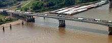
I-64 enters Illinois running concurrently with I–55 and U.S. Route 40 (US 40) over the Mississippi River on the Poplar Street Bridge. After splitting from these highways in East St. Louis, I-64 turns southeasterly and runs through St. Clair, Clinton, Washington, and Jefferson counties through a rural part of Illinois with no major cities or intersections.[2][1] The only major intersection outside of St. Louis is a short concurrency with I-57 near Mount Vernon. Past this, the Interstate enters another rural stretch through parts of Jefferson, Wayne, and White counties before crossing the Wabash River into Indiana.[2]
Exit list
| County | Location[3] | mi[1] | km | Exit[4] | Destinations[4] | Notes |
|---|---|---|---|---|---|---|
| Mississippi River | 0.0 | 0.0 | Poplar Street Bridge I-55 south / I-64 west / US 40 west continues into Missouri | |||
| St. Clair | East St. Louis | 0.6 | 0.97 | 1 |   IL 3 south / Great River Road south – Cahokia IL 3 south / Great River Road south – Cahokia | Western end of IL 3/GRR concurrency |
| 0.9 | 1.4 | — | 13th Street and Tudor Avenue | Unnumbered exit[5] | ||
| 1.3 | 2.1 | — | Barack Obama Avenue – Business District | Unnumbered exit[5] | ||
| 2.5 | 4.0 | 2 |  I-55 north / I-70 east / US 40 – Chicago, Indianapolis I-55 north / I-70 east / US 40 – Chicago, Indianapolis | Eastern end of I-55/US 40 concurrency | ||
| 2.7 | 4.3 | 3 | IL 3 north / Great River Road north (St. Clair Avenue) | Eastern end of IL 3/GRR concurrency | ||
| 3.3 | 5.3 | 4 | 15th Street | |||
| 4.2 | 6.8 | 5 | 25th Street | |||
| Washington Park | 5.8 | 9.3 | 6 |  IL 111 (Kingshighway) IL 111 (Kingshighway) | ||
| Caseyville | 7.1 | 11.4 | 7 |   I-255 / US 50 west – Memphis, Chicago I-255 / US 50 west – Memphis, Chicago | Western end of US 50 concurrency | |
| 8.4 | 13.5 | 9 |  IL 157 – Caseyville, Centreville IL 157 – Caseyville, Centreville | |||
| Fairview Heights | 12.0 | 19.3 | 12 |  IL 159 – Belleville, Collinsville IL 159 – Belleville, Collinsville | ||
| O'Fallon | 14.2 | 22.9 | 14 | Old US 50 – O'Fallon | ||
| 15.7 | 25.3 | 16 | Green Mount Road – O'Fallon, Shiloh | |||
| 18.6 | 29.9 | 19 |  US 50 east / IL 158 west – Carlyle, Scott Air Force Base US 50 east / IL 158 west – Carlyle, Scott Air Force Base | Eastern end of US 50 concurrency; northern terminus of IL 158; signed as exits 19A (west) and 19B (east) | ||
| Mascoutah | 22.6 | 36.4 | 23 |  IL 4 – Mascoutah, Lebanon IL 4 – Mascoutah, Lebanon | ||
| New Baden | 27.1 | 43.6 | 27 |  IL 161 – New Baden IL 161 – New Baden | ||
| Clinton | | 34.2 | 55.0 | 34 | Albers | |
| Washington | | 40.4 | 65.0 | 41 |  IL 177 – Okawville IL 177 – Okawville | |
| Nashville | 49.8 | 80.1 | 50 |  IL 127 – Carlyle, Nashville IL 127 – Carlyle, Nashville | ||
| | 60.7 | 97.7 | 61 |  US 51 – Centralia, Ashley US 51 – Centralia, Ashley | ||
| Jefferson | | 68.6 | 110.4 | 69 | Woodlawn | |
| Mount Vernon | 73.3 | 118.0 | 73 |  I-57 north – Chicago I-57 north – Chicago | Western end of I-57 concurrency; I-64 uses I-57 exit numbers | |
| 74.8 | 120.4 | 95 |   IL 15 – Mount Vernon, Ashley IL 15 – Mount Vernon, Ashley | |||
| | 75.8 | 122.0 | 94 | Veterans Memorial Drive | ||
| | 78.0 | 125.5 | 92 | I-57 south – Memphis | Eastern end of I-57 concurrency | |
| | 79.7 | 128.3 | 80 |  IL 37 – Mount Vernon IL 37 – Mount Vernon | ||
| | 88.5 | 142.4 | 89 | Belle Rive, Bluford | ||
| Wayne | | 99.3 | 159.8 | 100 |  IL 242 – Wayne City IL 242 – Wayne City | |
| | 110.1 | 177.2 | 110 |  US 45 – Mill Shoals US 45 – Mill Shoals | ||
| White | | 116.7 | 187.8 | 117 | Burnt Prairie | |
| Grayville | 129.4 | 208.2 | 130 |  IL 1 – Grayville IL 1 – Grayville | ||
| Wabash River | 130.4 | 209.9 | I-64 east continues into Indiana | |||
1.000 mi = 1.609 km; 1.000 km = 0.621 mi
| ||||||
References
- 1 2 3 4 Google (August 2, 2014). "Overview map of Interstate 64 in Illinois" (Map). Google Maps. Google. Retrieved August 2, 2014.
- 1 2 Interstate Exit Numbers of Illinois (PDF) (Map). Illinois Department of Transportation. November 2008.
- ↑ Town/City Boundary Map (Map). Cartography by Google, Inc. Google, Inc. Retrieved August 2, 2014 – via John Coryat.
- 1 2 "I-64 Illinois Exits Eastbound". Roadnow. 2014. Retrieved August 2, 2014.
- 1 2 "Interstate 64". AARoads.com. AARoads. 2014. Retrieved August 2, 2014.
| Interstate 64 | ||
|---|---|---|
| Previous state: Missouri |
Illinois | Next state: Indiana |