Interstate 85 Business (North Carolina)
| |
|---|---|
|
Route of Business 85 highlighted in red | |
| Route information | |
| Length: | 43.5 mi[1] (70.0 km) |
| Existed: | 1984 – present |
| Major junctions | |
| South end: |
    I‑85 / US 29 / US 52 / US 70 near Lexington I‑85 / US 29 / US 52 / US 70 near Lexington |
|
  I‑40 / US 29 / US 70 / US 220 in Greensboro I‑40 / US 29 / US 70 / US 220 in Greensboro | |
| North end: |
 I‑40 / I‑85 / I‑785 near McLeansville I‑40 / I‑85 / I‑785 near McLeansville |
| Location | |
| Counties: | Davidson, Randolph, Guilford |
| Highway system | |

_map.svg.png)
In the U.S. state of North Carolina, Interstate 85 Business (commonly known as Business 85) is a 43.5-mile-long (70.0 km) business loop of Interstate 85; which serves several cities in the Piedmont Triad.
Route description
Business 85 is known widely as having two sections that appears split by I-85 in Greensboro; it is actually one continuous route that is simply hidden on the 2-mile (3.2 km) stretch of I-85. For almost the entire route, US 29 and US 70 are cosigned.
Southern section
Business 85 begins from exit 87 of I-85, just south of Lexington. It travels along US 52 north then splits from it at exit 87. Becoming a semi-limited expressway, it travels through Lexington with a short concurrency with US 64. Once past Lexington, the road becomes a more typical expressway, with at grade intersections with some controlled interchanges throughout the rest of the southern section. Business 85 goes at a northeast direction, parallel to I-85 further south, as it goes through Thomasville and High Point. It makes a unique intersection with I-74/US 311 by having a full interchange, but with at-grade intersections at the ramps. After 30 miles (48 km), Business 85 merges with I-85 in Greensboro.
Northern section
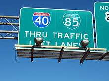
Business 85 continues again from exit 120A of I-85, in Greensboro. Continuing a northeast direction, it connects with I-40 at a location commonly nicknamed as "Death Valley"; creating a rarely seen concurrency of an interstate highway and a business loop signed together. Overlapped with I-40, it goes east until it meets I-85 for a third time near McLeansville, where it ends. The entire northern section is 6-lane freeway grade; though because it goes through the city of Greensboro, travelers can anticipate typical weekday rush hour slow downs (7:00-9:30 a.m./4:00-6:30 p.m.).
Dedicated and memorial names
I-85 Business features one dedicated stretch of freeway.
- Preddy Boulevard – Official North Carolina name of I-85 Business, from mile marker 33-36, in Greensboro. It is named after the Preddy Brothers (one of which is George Preddy), for their outstanding service in World War II.[2]
History
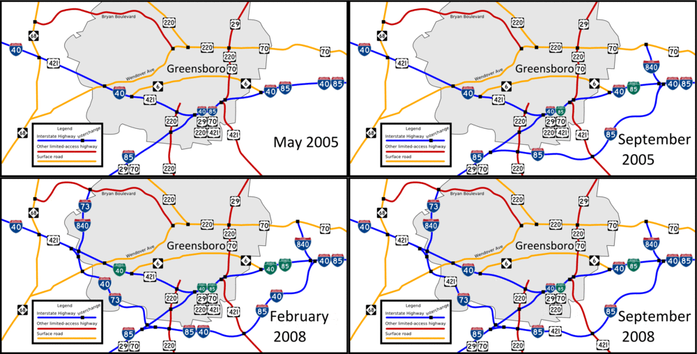
Established in 1984, I-85 Business was a replacement of Temp I-85, from Lexington to Greensboro, when Interstate 85 was completed on an east parallel routing. It also had a complete concurrency with US 29/US 70. In 2005, I-85 was redirected southeast around Greensboro along the Greensboro Urban Loop; its old route through Greensboro became an extension of I-85 Business. With an hidden overlap along I-85 between exits 118-120A, it continues to north then east through Greensboro, with a shared concurrency with I-40 (which briefly became I-40 Business, from February-September, 2008).
Temporary Interstate 85

| |
|---|---|
| Location: | Lexington-Greensboro, NC |
| Length: | 30.8 mi[3] (49.6 km) |
| Existed: | 1961–1984 |
Temporary Interstate 85 (Temp I-85) was established by 1961 as a temporary designation that directed travelers along US 29/US 70, from the Yadkin River to Greensboro.[4] In 1977, a flyover bridge was completed (dubbed "bridge over nothing," it later became part of I-85 exit 87), truncating Temp I-85 south-end near Lexington.[5][6] In 1984, I-85 was completed on new primary routing between Lexington and Greensboro; Temp I-85 was replaced by I-85 Business.
Exit list
| County | Location | mi[1] | km | Exit | Destinations | Notes |
|---|---|---|---|---|---|---|
| Davidson | Lexington | 0.0 | 0.0 | — | I‑85 south / US 29 south / US 52 south / US 70 west – Salisbury, Charlotte | Continuation as I-85/US 29/US 52/US 70; southbound exit and northbound entrance |
| 1.0 | 1.6 | 84 |  NC 47 east to I‑85 north – Linwood NC 47 east to I‑85 north – Linwood | To Davidson County Airport | ||
| 1.9 | 3.1 | 85 | Green Needles Road | |||
| 3.1 | 5.0 | 86 | Salisbury Road – Downtown Lexington | |||
| 4.4 | 7.1 | 87 | US 52 north – Winston-Salem | North end of US 52 overlap; northbound exit and southbound entrance | ||
| 5.1 | 8.2 | Old US 64 | ||||
| 5.6 | 9.0 |  US 64 west – Mocksville US 64 west – Mocksville | West end of US 64 overlap | |||
| 6.6 | 10.6 |  NC 8 (Winston Road) – Lexington, Winston-Salem NC 8 (Winston Road) – Lexington, Winston-Salem | ||||
| 7.3 | 11.7 | US 64 east – Asheboro | East end of US 64 overlap | |||
| Thomasville | 14.7 | 23.7 | Lexington Avenue – Thomasville | Northbound exit and southbound entrance | ||
| 17.1 | 27.5 |  NC 109 (Salem Street) – Thomasville, Winston-Salem NC 109 (Salem Street) – Thomasville, Winston-Salem | ||||
| 18.7 | 30.1 |  NC 68 (National Highway) – Thomasville, West High Point NC 68 (National Highway) – Thomasville, West High Point | To Piedmont Triad International Airport | |||
| Randolph | High Point | 20.0 | 32.2 | Old Thomasville Road – High Point | ||
| Guilford | 20.7 | 33.3 | Prospect Street | |||
| 21.6 | 34.8 | West Green Drive | ||||
| 22.4 | 36.0 | Surrett Drive | ||||
| 23.1 | 37.2 | Main Street – High Point | ||||
| 24.5 | 39.4 |   I‑74 / US 311 / Brentwood Street – Winston-Salem, Asheboro I‑74 / US 311 / Brentwood Street – Winston-Salem, Asheboro | Brentwood Street has a separate exit northbound; three-level diamond interchange | |||
| 25.5 | 41.0 | Baker Road | ||||
| 26.6 | 42.8 | Kivett Drive – East High Point | ||||
| Greensboro | 29.2 | 47.0 | Vickery Chapel Road / Guildford College Road – Jamestown | |||
| 30.7 | 49.4 | 118 | I‑85 south – Salisbury, Charlotte | South end of I-85 overlap | ||
| 31.7 | 51.0 | 119 | Groometown Road to Grandover Parkway | Southbound exit incorporated with exit 33 | ||
| 32.6 | 52.5 | 120A 33 |  I‑85 north / US 421 south to I‑40 east – Durham, Sanford I‑85 north / US 421 south to I‑40 east – Durham, Sanford I‑73 north / US 421 north to I‑40 west / Groometown Road – Winston-Salem I‑73 north / US 421 north to I‑40 west / Groometown Road – Winston-Salem | North end of I-85 overlap; southbound exit and northbound entrance | ||
| 33.5 | 53.9 | 34 | Holden Road | |||
| 34.3 | 55.2 | 35 A-B | A: US 220 south to I‑73 south – Asheboro B: US 220 north to I‑40 west – Coliseum Area | No southbound exit 35B | ||
| 34.9 | 56.2 | 35C | Rehobeth Church Road / Vandalia Road | |||
| 35.8 | 57.6 | 219 | I‑40 west / US 220 south – Winston-Salem | West end of I-40 overlap; no northbound exit | ||
| 36.0 | 57.9 | 220 | Randleman Road | Left southbound entrance | ||
| 36.6 | 58.9 | 221 | South Elm-Eugene Street – Downtown Greensboro | |||
| 37.8 | 60.8 | 222 | Martin Luther King Jr. Drive | |||
| 38.1 | 61.3 | 223 | US 29 north / US 70 east / US 220 north – Reidsville | North end of US 29/US 220 and east end of US 70 overlap; northbound exit and southbound entrance | ||
| 40.1 | 64.5 | 224 | To US 29 north / US 220 north / East Lee Street | To Bennett College, UNC Greensboro, A&T University and Greensboro College | ||
| 42.5 | 68.4 | 226 | McConnell Road | |||
| 42.9 | 69.0 | 227 | I‑85 south / I‑785 north – Danville, Charlotte | Hidden west I-840 | ||
| 43.5 | 70.0 | — | I‑40 east / I‑85 north – Raleigh, Durham | Continuation as I-40/I-85 | ||
1.000 mi = 1.609 km; 1.000 km = 0.621 mi
| ||||||
References
- 1 2 Google (January 28, 2011). "I-85 Business in NC" (Map). Google Maps. Google. Retrieved January 28, 2011.
- ↑ "North Carolina Memorial Highways and other Named Facilities" (PDF). North Carolina Department of Transportation. July 15, 2004. Retrieved April 17, 2014.
- ↑ Google (April 17, 2014). "Temporary Interstate 85" (Map). Google Maps. Google. Retrieved April 17, 2014.
- ↑ 1970 North Carolina Official Highway Map (PDF) (Map). Cartography by NCDOT. North Carolina Department of Transportation. 1970. Retrieved April 17, 2014.
- ↑ "Uglybridges.com: US29&70/I-85 BUS LP over I-85". Retrieved April 17, 2014.
- ↑ 1979-80 North Carolina Transportation Map & Guide to Points of Interest (PDF) (Map). Cartography by NCDOT. North Carolina Department of Transportation. 1979. Retrieved April 17, 2014.
External links
-
 Media related to Interstate 85 Business (North Carolina) at Wikimedia Commons
 - NCRoads.com: I-85 Business
- NCRoads.com: I-85 Temp
| ||
| ||
