Cristóbal Island
| Native name: <span class="nickname" ">Isla San Cristóbal | |
|---|---|
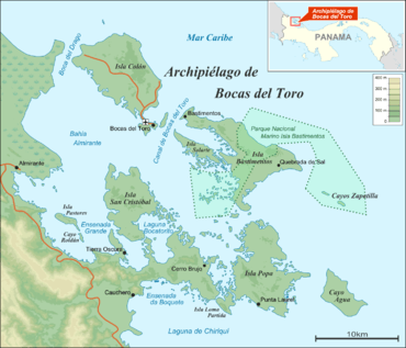 Bocas del Toro Archipelago | |
| Geography | |
| Coordinates | 9°21′N 82°14′W / 9.350°N 82.233°WCoordinates: 9°21′N 82°14′W / 9.350°N 82.233°W |
| Archipelago | Bocas del Toro Archipelago |
| Area | 37 km2 (14 sq mi) |
| Highest elevation | 0 m (0 ft) |
| Administration | |
| Province | Bocas del Toro |
| District | Bocas del Toro |
Cristóbal Island (in Spanish: Isla San Cristóbal, or Christopher's Island the Spanish rendition of Christopher Columbus' name) is a mostly deforested 37 km2 island located south of Isla Colón,[1] in the Bocas del Toro Archipelago, Panama. It is home to the indigenous Ngäbe or Guaymí people and a small number of expatriates.
Laguna Bocatorito, also known as Dolphin Bay, lies on the east side of the island.
See also
References
- ↑ Jisel Perilla (2008), Frommer's Panama, Frommers, p. 282, ISBN 0-470-37183-8
| Islands |  | |
|---|---|---|
| Protected areas | ||
| Settlements |
| |
This article is issued from Wikipedia - version of the 11/17/2016. The text is available under the Creative Commons Attribution/Share Alike but additional terms may apply for the media files.