Iytwelepenty / Davenport Range National Park
| Iytwelepenty / Davenport Range National Park Northern Territory | |
|---|---|
|
IUCN category II (national park) | |
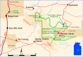 Iytwelepenty/Davenport Range National Park (outlined in green) | |
| Nearest town or city | Tennant Creek |
| Established | 1993 |
| Area | 1,278.47 km2 (493.6 sq mi)[1] |
| Managing authorities | Department of Natural Resources, Environment, the Arts and Sport |
| Website |
Iytwelepenty |
| See also | Protected areas of the Northern Territory |
Iytwelepenty / Davenport Range is a national park in the Northern Territory (Australia), 1033 km southeast of Darwin.[2] Amelia Creek crater, an ancient eroded impact crater lies within the Davenport Range in the area.
See also
References
- ↑ "CAPAD 2012 Northern Territory Summary (see 'DETAIL' tab)". CAPAD 2012. Australian Government - Department of the Environment. 7 February 2014. Retrieved 7 February 2014.
- ↑ Hema, Maps (2007). Australia Road and 4WD Atlas (Map). Eight Mile Plains Queensland: Hema Maps. p. 101. ISBN 978-1-86500-456-3.
External links
Coordinates: 20°51′36″S 134°56′28″E / 20.8600°S 134.9410°E
This article is issued from Wikipedia - version of the 4/6/2016. The text is available under the Creative Commons Attribution/Share Alike but additional terms may apply for the media files.