K-194 (Kansas highway)
| ||||
|---|---|---|---|---|
| Route information | ||||
| Maintained by KDOT | ||||
| Length: | 1.580 mi[1] (2.543 km) | |||
| Existed: | c. 1956[2] – present | |||
| Major junctions | ||||
| South end: | Simpson city limits | |||
| North end: |
 US-24 north of Simpson US-24 north of Simpson | |||
| Location | ||||
| Counties: | Cloud, Mitchell | |||
| Highway system | ||||
| ||||


K-194 is a state highway in northern Kansas. It links U.S. Route 24 (US-24) to the city of Simpson, where it terminates. The entire 1.58-mile-long (2.54 km) route straddles the Cloud–Mitchell county line. The highway travels in a north–south direction, and is a two-lane road for its entire length.
The route was designated between 1953 and 1956 when US-24 was realigned to bypass Simpson.
Route description
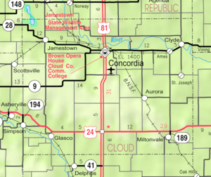
K-194 begins at the northern city limit of Simpson, marked by the Kyle Railroad.[3] The route travels due north on a two-lane road across a flat, treeless plain for 1.58 miles (2.54 km) before terminating at an intersection with US-24. All of the designation lies on the Cloud–Mitchell county line.[4]
K-194 is maintained by the Kansas Department of Transportation. In 2012, the route's average annual daily traffic was 415 vehicles, including 40 trucks.[5] The route is not included in the National Highway System,[6] a system of highways important to the nation's defense, economy, and mobility.[7]
History
Between 1953 and 1956, US-24 was realigned to bypass the city of Simpson. K-194 was designated on the roadway that formerly carried US-24 from Simpson to a point north of the city where it curved to the west. The route was paved at the time it was designated.[2][8] The route has not changed since designation.[9]
Major intersections
The entire route is on the Cloud–Mitchell county line.
| Location | mi[1] | km | Destinations | Notes | |
|---|---|---|---|---|---|
| Simpson | 0.000 | 0.000 | Northern city limit | Southern terminus | |
| | 1.580 | 2.543 | US-24 | Northern terminus | |
| 1.000 mi = 1.609 km; 1.000 km = 0.621 mi | |||||
Map
References
- 1 2 Kansas Department of Transportation. "2012 Condition Survey Report". Retrieved December 28, 2012.
- 1 2 Official 1956 Kansas Highway Map (PDF) (Map). State Highway Commission of Kansas. Retrieved December 28, 2012.
- ↑ Kansas Railroad Map 2011 (PDF) (Map). Kansas Department of Transportation. Retrieved December 28, 2012.
- ↑ Google (December 28, 2012). "K-194 (Kansas highway)" (Map). Google Maps. Google. Retrieved December 28, 2012.
- ↑ Traffic Flow Map of the Kansas State Highway System (PDF) (Map). Kansas Department of Transportation. 2012. Retrieved December 28, 2012.
- ↑ National Highway System: Kansas (PDF) (Map). Federal Highway Administration. 2012. Retrieved December 28, 2012.
- ↑ Natzke, Stefan; Neathery, Mike; Adderly, Kevin (September 26, 2012). "What is the National Highway System?". National Highway System. Federal Highway Administration. Retrieved December 31, 2012.
- ↑ Official 1953 Kansas Highway Map (PDF) (Map). State Highway Commission of Kansas. Retrieved December 28, 2012.
- ↑ Kansas Official Transportation Map (PDF) (Map). Kansas Department of Transportation. 2011–2012. Archived from the original (PDF) on February 2, 2014. Retrieved December 28, 2012.