Kachaghakaberd
| Կաչաղակաբերդ | |
 | |
| Location | Nagorno-Karabakh |
|---|---|
| Type | Fortress, in the Principality of Khachen |
| Completion date | 9th century |
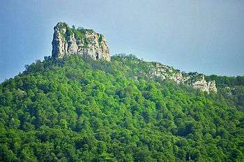
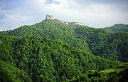
Kachaghakaberd (Armenian: Կաչաղակաբերդ) is a mountain-top fortress in the Martakert Province of the unrecognized Nagorno-Karabakh Republic within Azerbaijan, where it lies in the Tartar Rayon.[1][2]
Architecture
The fortress was an important fortification of the medieval Armenian Principality of Khachen that thrived in the High Middle Ages [3] and is located at a height of more than 1700 meters, surrounded by vertical limestone cliffs with the heights of 50–60 meters, has a hard-to-reach entrance from the southern side of the fortress. During its history no one could ever storm the fortress. Parts of the defensive walls remain standing.[4]
The territory of the fortress occupies a large area, though it seems small. Many rooms, secret passages cut into the cliffs, and special "loopholes" for throwing stones at enemies are inside its territory.[5] The water supply problem was solved by a unique method: two rock-cut reservoirs to store rain and melt-water are in the center of the fortress. Fresh water was brought from a spring at the foot of the mountain.[6]
Etymology
Kachaghakaberd is translated from Armenian as magpie's fortress, a combination of the words կաչաղաք (kachaghak, designating the bird magpie) and բերդ (berd, meaning fortress).[7][8]
Gallery
See also
References
- ↑ "Качагакаберд".
- ↑ "Качагакаберд (крепость)".
- ↑ Bonnie Marshall. The Flower of Paradise and Other Armenian Tales (World Folklore Series). 2007. photo section
- ↑ Boris Baratov. Paradise Laid Waste: A Journey to Karabakh, Lingvist Publishers, Moscow, 1998, pp. 50
- ↑ Shahen Mkrtchian. Historical and Architectural Monuments of Nagorno-Karabakh. pp. 10, 21, 25. Yerevan, 1989, in Russian. Original: Шаген Мкртчян. Историко-архитектурные памятники Нагорного Карабаха. стр. 10, 21, 25. Ереван, 1989
- ↑ Brady Kiesling (Author), Raffi Kojian (Author, Editor). Rediscovering Armenia. Publisher: Matit; 2nd edition (June 1, 2005), ISBN 9994101218; ISBN 978-9994101214
- ↑ Brady Kiesling (Author), Raffi Kojian (Author, Editor). Rediscovering Armenia. Publisher: Matit; 2nd edition (June 1, 2005), ISBN 9994101218; ISBN 978-9994101214
- ↑ Shahen Mkrtchian. Historical and Architectural Monuments of Nagorno-Karabakh. pp. 10, 21, 25. Yerevan, 1989, in Russian. Original: Шаген Мкртчян. Историко-архитектурные памятники Нагорного Карабаха. стр. 10, 21, 25. Ереван, 1989
Coordinates: 40°00′24″N 46°35′57″E / 40.0067°N 46.5992°E