Kelk, East Riding of Yorkshire
| Kelk | |
|---|---|
| Civil parish | |
 | |
| Coordinates: 54°01′N 0°19′W / 54.017°N 0.317°WCoordinates: 54°01′N 0°19′W / 54.017°N 0.317°W | |
| Country | England |
| Primary council | East Riding of Yorkshire |
| Region | Yorkshire and the Humber |
| Status | Parish |
| Government | |
| • Type | Parish Council |
| • UK Parliament | East Yorkshire |
| • EU Parliament | Yorkshire and the Humber |
| Population (2011 census)[1] | |
| • Total | 158 |
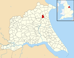
Kelk is a civil parish in the East Riding of Yorkshire, England. It is situated 7 miles (11 km) to the south-west of Bridlington town centre and covering an area of 768.523 hectares (1,899.06 acres).[2]
The civil parish is formed by the village of Great Kelk and the hamlet of Little Kelk.
According to the 2011 UK census, Kelk parish had a population of 158,[1] a decrease on the 2001 UK census figure of 180.[3]
References
- 1 2 "Key Figures for 2011 Census: Key Statistics: Area: Kelk CP (Parish)". Neighbourhood Statistics. Office for National Statistics. Retrieved 5 February 2013.
- ↑ "2001 Census Area Profile" (PDF). East Riding of Yorkshire County Council. 2004. Archived (PDF) from the original on 18 March 2012. Retrieved 8 February 2013.
- ↑ "2001 Census: Key Statistics: Parish Headcounts: Area: Kelk CP (Parish)". Neighbourhood Statistics. Office for National Statistics. Retrieved 12 March 2008.
- Gazetteer — A–Z of Towns Villages and Hamlets. East Riding of Yorkshire Council. 2006. pp. 6–8.
 |
Wikimedia Commons has media related to Kelk. |
This article is issued from Wikipedia - version of the 9/9/2016. The text is available under the Creative Commons Attribution/Share Alike but additional terms may apply for the media files.